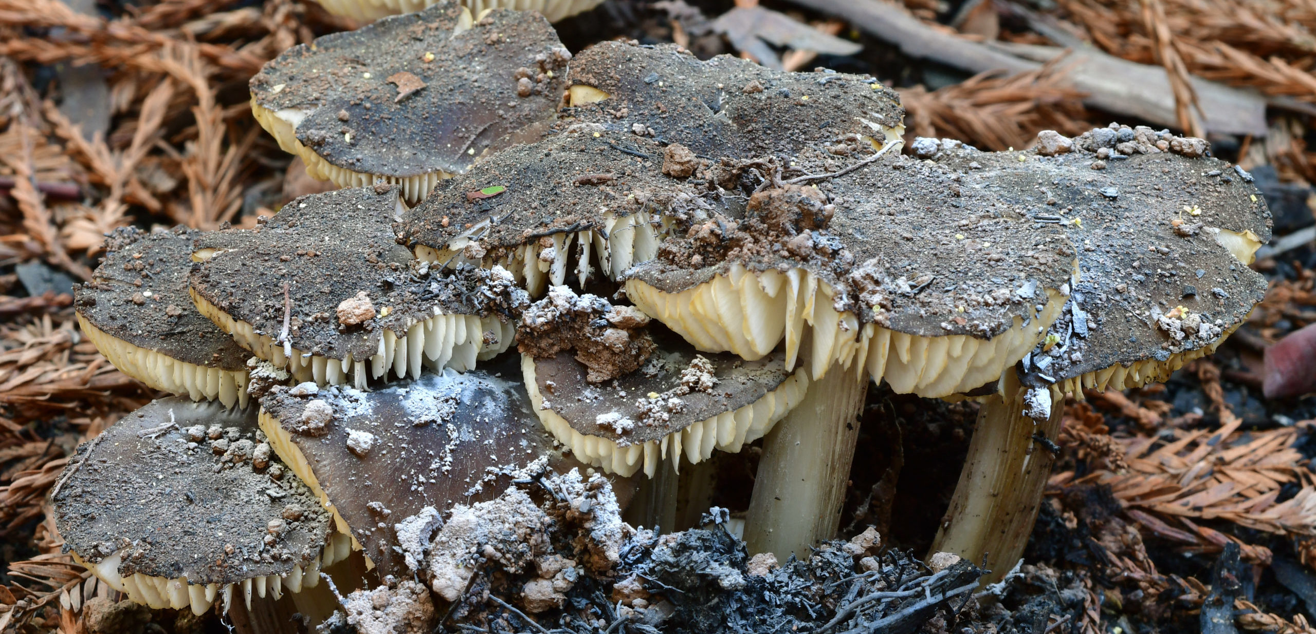
As mushroom hunters, we enjoy traveling far and wide, bouncing from place to place and following the rains to stay with the season. But what happens when we focus on revisiting the same small areas whether there has been rain or not? And what if we take it a step further, and rather than just harvesting chanterelles or photographing the flashiest species, we take the time to pay attention to everything, counting individual fruitbodies and keeping track of changes from year to to year?
Christian Schwarz has been undertaking just such an effort for the past three years, supported by a grant from the Save the Redwoods League, and this year, some of his survey transects were burned in the CZU Lightning Complex fires. Join the Kenneth S. Norris Center for Natural History, the San Lorenzo Valley Museum, and the Santa Cruz Museum of Natural History to hear what discoveries, lessons, and patterns have emerged from this ambitious project.
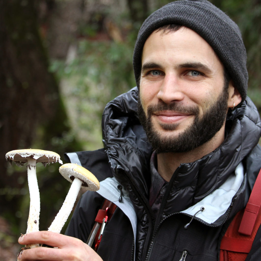
Christian Schwarz is a naturalist currently living in Santa Cruz, the land of milk (caps) and honey (mushrooms). He studied Ecology and Evolution at UCSC, and now spends his time photographing, teaching about, collecting, and researching macrofungi. He is coauthor of Mushrooms of the Redwood Coast. Fungi satisfy his curiosity with their seemingly endless forms – from the grotesque to the bizarre to the sublimely beautiful. Besides dabbling in mushroom taxonomy, he loves fish, plants, nudibranchs, moths, and dragonflies. He is passionate about citizen science, especially iNaturalist.
This program is part of a series in support of the exhibit Look. Act. Inspire. and is presented in partnership between
In this installation of Rock Record, we explore how faults shape Santa Cruz. First, a little about faults.
By Graham Edwards and Gavin Piccione (aka the Geology Gents)
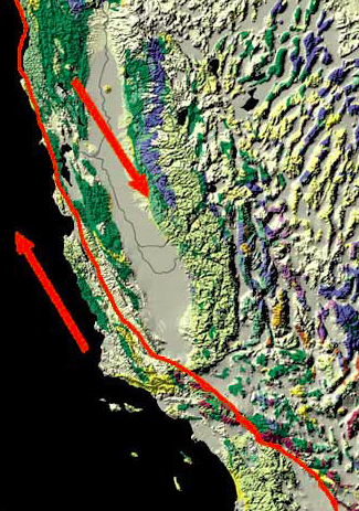
Image: San Andreas Fault. Credit: Kate Borton, David Howell, and Joe Vigil.
Faults are flat fracture surfaces within rock where portions of the rock move past each other. These features are some of the most prominent ways geologic processes shape the surface of the Earth. Motion along faults is responsible for the creation of most of the Earth’s mountains and valleys; faults significantly impact how and where rocks are eroded; and motion across faults causes earthquakes. In California, the most iconic fault is the continent-scale San Andreas Fault, but faults in this area occur at a wide range of sizes and often create familiar landscape features.
The Creation of the Santa Cruz Mountains
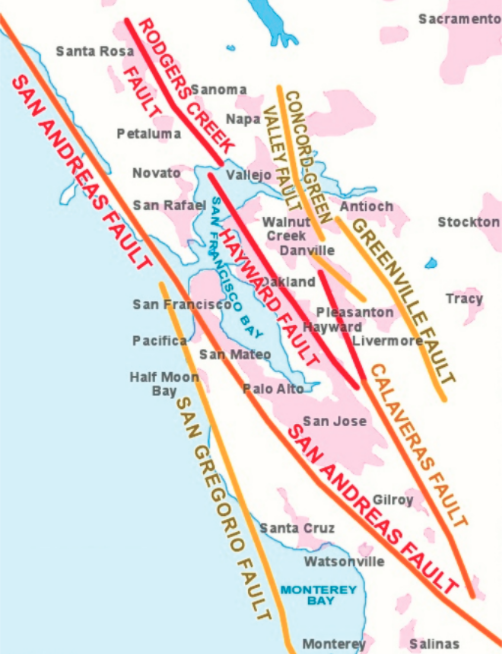
Faults of the Bay Area. Credit: UC Berkeley Seismology Lab.
Plate tectonics drive fault motion, creating large fracture surfaces in the Earth’s crust as the plates move apart, alongside, or crash into each other. Along the San Andreas, this plate motion is primarily horizontal (side-to-side), as the Pacific plate moves North and the North American plate moves South.
Major faults like the San Andreas are not actually one single fault, and instead make up fault zones, or networks of parallel faults that take up portions of the overall motion. Regional scale plate motion, like that responsible for the San Andreas, is often taken up by branching fault networks, instead of by one single fault zone. In the San Francisco Bay Area, the North-South motion of the Pacific and North American plate is taken up by four major faults: San Andreas, San Gregorio, Hayward, and Calaveras (right).
A careful look at the trace of the main San Andreas Fault reveals that this fault is not perfectly straight, but rather curves and wiggles a little bit. This complicates the motion of the fault. It is easy to slide two flat blocks past one another, but if you add bumps to these blocks, they are much harder to move. This is because when these bumps run into each other, they catch on one another. When these bumps are small (like sandpaper) it makes the fault hard to move. When these bumps are large, like the bend of the San Andreas Fault just north of Santa Cruz, the landscape in that bend can get squeezed together or pulled apart. Given the left-to-right motion of the San Andreas, the bend North of Santa Cruz squeezes the landscape together, thickening the crust and pushing the Earth upward to form the Santa Cruz Mountains.
The Faults in our Backyard
The Ben Lomond fault is the largest fault running through Santa Cruz, starting offshore in the Monterey Bay and weaving its way up into the Santa Cruz Mountains. Geologists know this fault was last active over 85,000 years ago, since it cuts through the older Purisima Sandstone and Santa Margarita Sandstone but does not disrupt the younger marine terrace deposits. The Ben Lomond fault is responsible for the path of the San Lorenzo river, which took advantage of rock that was fractured and weakened by motion along the fault.
Geologists from UCSC mapped the fault through Santa Cruz in the 1980’s, and for this installation of Rock Record we tracked the areas where this fault is visible from West Cliff drive up through Felton.
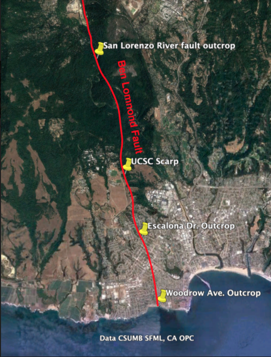
West Cliff Outcrop
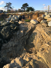
The Ben Lomond fault first outcrops (geologist jargon for becomes visible in rock) on West Cliff Dr. in Santa Cruz, at the end of Woodrow Avenue, just west of Mitchell’s Cove Beach. This outcrop is a subtle, tight notch in the cliff. When compared to other rocks along the sea cliff, the rocks in the Woodrow Ave. outcrop are much more fractured, which is a result of more intense rock deformation caused by motion along the fault. Note, the large, dark boulders along this section of the cliff were placed there to prevent erosion.
Escalona Dr. Outcrop
Because the Ben Lomond fault is younger than the marine rocks that make up most of Santa Cruz, evidence of its existence does not appear in many areas South of Felton. One exception is along Escalona Dr., where the fault creates a small notch in the north side of street on private property.
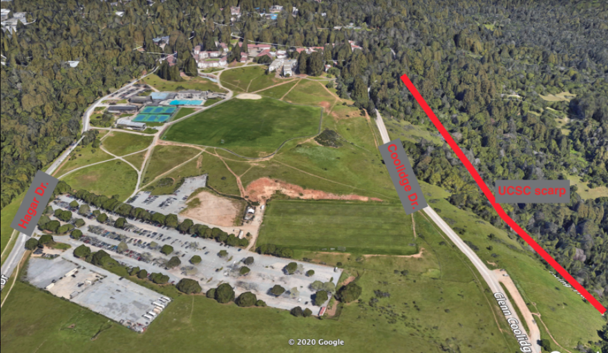
Fault Scarp on UCSC campus
While an outcrop of the Ben Lomond fault is not visible between Escalona Dr. and Felton, evidence of motion along the fault can be seen along Coolidge Dr. on the UCSC campus. On the west side of the road, there is a steep drop down into Pogonip park. This ledge, termed a fault scarp, was made by motion along the Ben Lomond fault, where the east side of the fault was push upwards and the west side downwards.
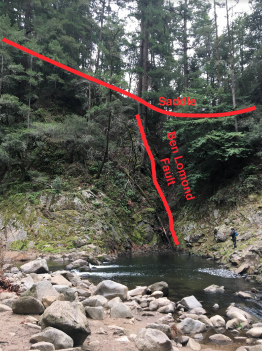
Outcrop Along the San Lorenzo in Henry Cowell State Park
North of UCSC, the Ben Lomond fault runs parallel (and sometimes through) the San Lorenzo River. In Henry Cowell State park, just north of the “Garden of Eden” swimming hole, the Ben Lomond fault can be seen along the west bank of the river. While subtle, this outcrop has some of the tell-tale signs of fault activity. Similar to the West cliff outcrop, there is pronounced fracturing of the rock in this area. Additionally, topography on the west side of the river reaches a low-point, which geologists term a saddle, where the rocks are more eroded.
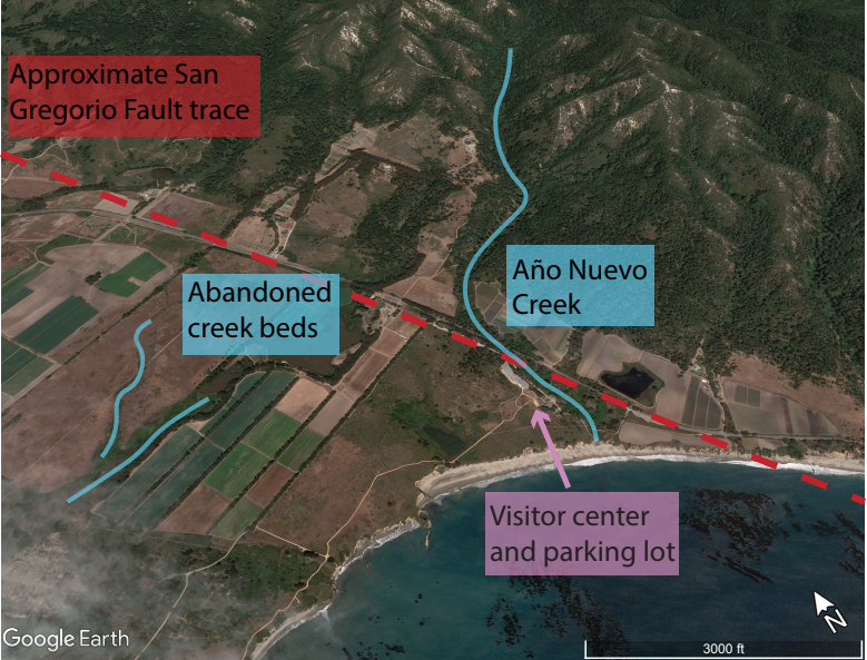
A Detour North: Año Nuevo Faults
While the faults around Santa Cruz can be subtle or hard to get to, you don’t need to travel far to see faults and evidence of their activity. Año Nuevo State Park lies on the land where the trace of the San Gregorio Fault strikes dry land again (south of here it follows the coast just offshore). The San Gregorio Fault continues on its right-ward progress, dragging the westward/seaward portions of Año Nuevo to the northwest. Looking down at Año Nuevo State Park from the air, you can see the work of the San Gregorio Fault plainly. Año Nuevo Creek, which drains out of the steep mountains here, passes right by the visitor center and creates a pleasant, sheltered beach where it meets the ocean. However, over geologic history, the last leg of Año Nuevo Creek kept getting pushed to the northwest. Eventually it got pushed so far out of the way of upper Año Nuevo Creek, that the creek abandoned the distant creek bed and found a new, more convenient route. Geologists call this streambed hopping avulsion. But the abandoned creek beds to the northwest of today’s creek show us that the San Gregorio Fault has been shifting everything to the right of their neighbors across the fault.
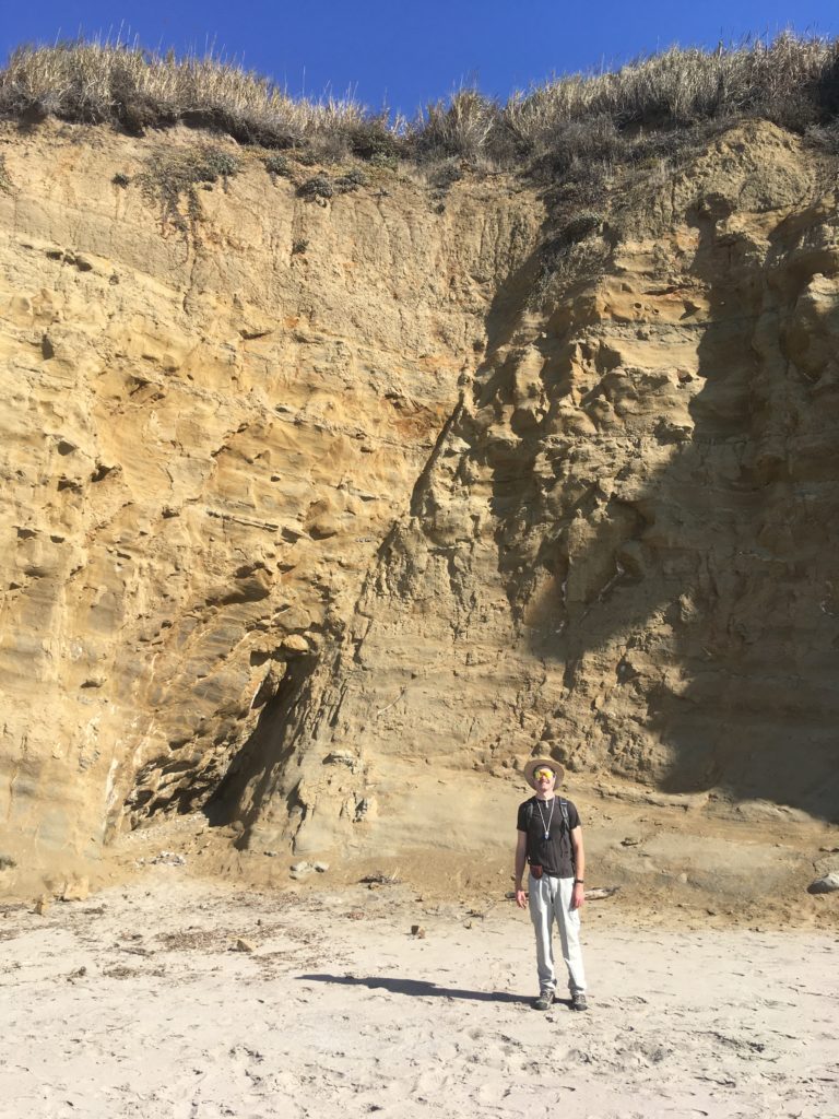
With the benefit of this birds’ eye view, let’s look a little bit closer and see what’s going on at human-scale. If you go from the visitor center (Marine Education Center) down along the Steele and New Years Creek Trails, you will arrive at the southern edge of Cove Beach, where Año Nuevo Creek reaches the ocean. If you continue southeast a short distance you come across a beautiful fault slicing across the sea cliff (below). This small little fault is not the San Gregorio Fault, but actually related to the nearby Año Nuevo Creek Fault which slices up the valley the creek flows down. As faults damage the rocks they cut through, they weaken the rock there, making it easy prey for an erosive mountain stream to chew into.
First creek fault.
We can even do a little geologic sleuthing. The fault clearly slices through the ancient sandy beach deposits on the top of the cliff, so we know the fault must be younger than those. Those sandy deposits are less than 100,000 years old, so we know this fault has moved in the last 100,000 years.
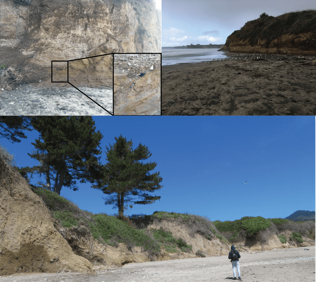
Let’s return to the creek, and look southeast toward Santa Cruz. Here you can see two different rocks pressed together There are light-colored pebbly rocks that meet with the familiar brown sandstone of the Purisima Formation along a jagged, sloping line of contact. The zig-zags of the contact are old stream banks where the ancient creek chewed into the rocky bank. Those pebbly rocks above the old stream banks are ancient deposits of Año Nuevo Creek. This means that today the Creek is now eroding back into them! If we get up close to the rocks, we can even find a variety of rocks including some charcoal that came from ancient fires and was washed away with rainwater before getting caught up in these streambank deposits.
Some of these chunks of charcoal have been dated using radiocarbon and give an age of around 10 thousand years old (unpublished data from this report). Since these deposits have 10,000 year old charcoal in them, they cannot be any older than 10,000 years. That is super young in geologic terms.
If we travel to the northwest toward Pescadero on Cove Beach we can follow these young creek deposits on the cliff and even see a few faults that cut through the rocks of the cliffs. As you come level with the “Pond” a few trees tower at the edge of the cliff. If you look closely here, you can see that the light pebbles fade into a messy zone of jumbled rock and eventually back into familiar Purisima sandstones. That messy zone of jumbled rock is none other than the Frijoles Fault. Since this fault slices through those 10,000 year old stream deposits, the fault must be younger than 10,000 years. Once again, in geologic terms, this is a young and active fault.
The sea cliffs along Cove Beach are a great place to do geologic detective work. Just remember that these sea cliffs are zones of active erosion and rockfalls may happen unexpectedly. When looking at rocky cliffs, always be careful, aware, and safe!
Rock Record is a monthly blog featuring musings on the mineral world from Gavin Piccione and Graham Edwards.
Graham Edwards and Gavin Piccione are PhD candidates in geochronology with the Department of Earth and Planetary Sciences at UC Santa Cruz. They also host our monthly Rockin’ Pop-Ups as “The Geology Gents”.
As winter temperatures drop below 50 °F, honey bees (Apis mellifera) will cluster in their hives in a bid to stay warm. In preparation for the winter, bees have to ensure that they have a sufficient supply of honey stored in their combs to see them through the long months when food sources are scarce. Honey is produced after bees ingest nectar from plants and then regurgitate it. This process leads to a product that is naturally sweet and easy to preserve.
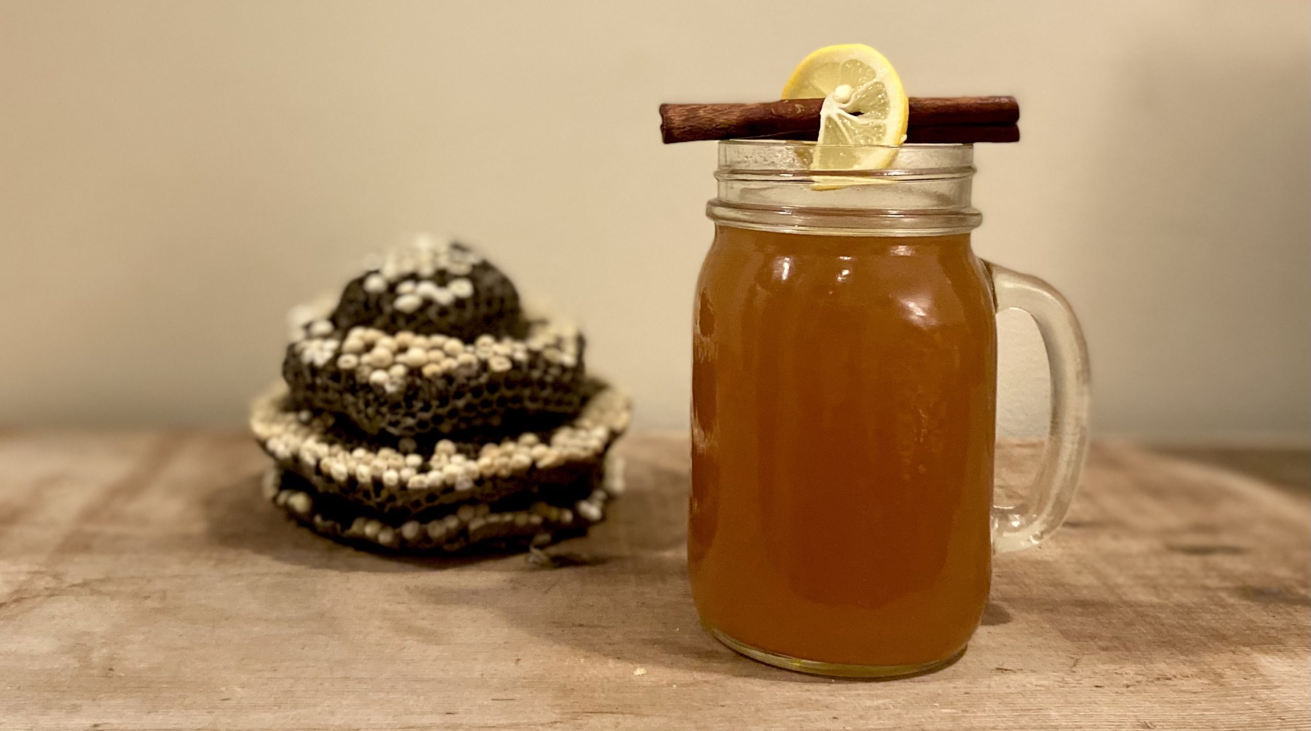
Much like honey bees in their hives, we humans can also appreciate staying in our homes to keep warm on a cold winter’s night, perhaps enhanced with a fortifying beverage. Hot toddies are traditionally a way to consume liquor that is warmed with hot water, honey and other spices. This particular recipe evokes an especially smoky flavor, reminiscent of beekeepers using smoke to calm their bees as they work on hives.
The flavor of honey can vary depending on which flowers bees have been collecting nectar from. Try different honeys from your local farmers market or grocery stores to enjoy subtle differences in your toddy recipes.
Ingredients
4 cups hot water
4 bags of black tea (try something like lapsang souchong for extra smoke flavor)
3 slices of lemon (save one for a garnish)
Juice of 1 lemon (2 tbsp)
2 cinnamon sticks
5-10 cloves
5-10 Black peppercorns
2-4 tbsp honey (adjust depending upon how sweet you prefer it)
A smoky liquor like scotch or mezcal
Serving size: 2-4 drinks depending upon the size of your mugs.
Instructions
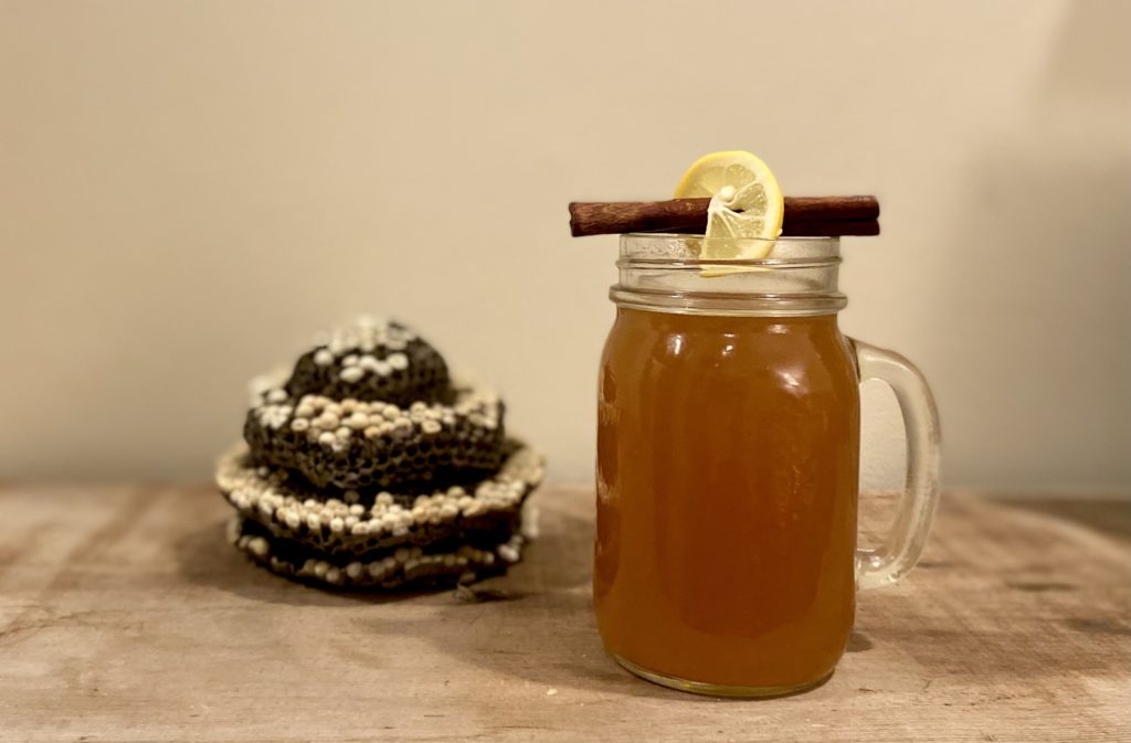
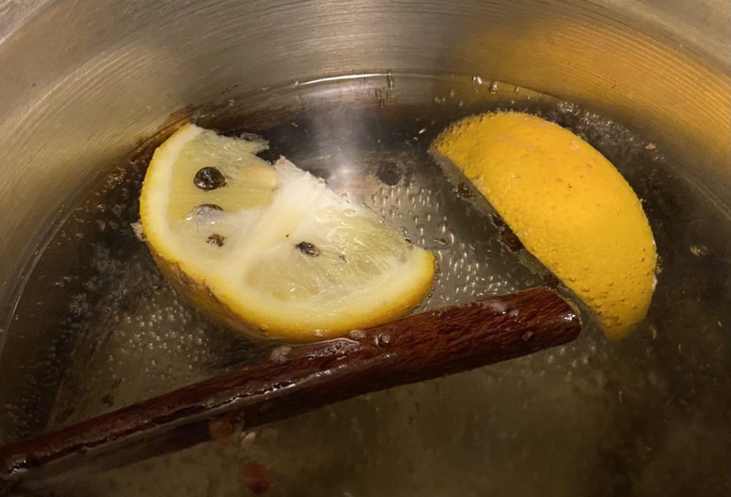
Put your water in a saucepan with the cinnamon sticks, and two lemon slices with cloves and peppercorns inserted into them (alternatively, put your spices in cheesecloth if you don’t want to strain them out later). Bring to a boil and simmer for 5-10 minutes to allow the spices to diffuse. Bring your pan off of the heat and add in the honey, lemon juice and tea bags. Make sure the honey dissolves completely and allow the tea to steep for 5 minutes. Serve in a mug with 1.5-2 oz. of an alcohol of your choice or leave it out for a cozy non-alcoholic option. Use cinnamon sticks and a lemon slice for garnish.
Want a version with more kick? Substitute the peppercorns for cayenne or steep a hot pepper in your water.
This month, the Geology Gents explore how varied volcanoes can be. Graham Edwards and Gavin Piccione, PhD candidates in geochronology at UC Santa Cruz, put on blast how lava type affects the appearance of volcanoes and the way those volcanoes erupt.
About the Series: Join the Geology Gents, Gavin and Graham, for monthly conversations about rocks live on Facebook. Each month we’ll explore a different geologic topic, from Santa Cruz formations to tips for being a more effective rockhound. Graham Edwards and Gavin Piccione are PhD candidates in geochronology with the Department of Earth and Planetary Sciences at UC Santa Cruz.
Submit your questions ahead of time by emailing events@santacruzmuseum.org and feel free to include pictures of rocks you’d like identified! Note: you do not need to have a Facebook account to be able to watch the program live.
Laura Hecox was an extraordinary woman and a brilliant amateur scientist who even had species named after her. Laura was the Santa Cruz lighthouse keeper from 1883 to 1916, and a renowned collector whose lighthouse museum was known far and wide. Contemporary descriptions in newspapers, correspondence, and other publications describe a stunning collection that occupied a room’s worth of cabinets on subjects from marine life to gems and minerals to ethnographic collections. Her collection of natural history specimens, artifacts, and curios was gifted to the people of Santa Cruz in 1904 and is the foundational collection of the Santa Cruz Museum of Natural History.
Over the years, as Laura’s museum found homes in different community locations, portions of the collection were lost to time. Today, we strive to reconcile this loss with the honor of preserving what we still have, and the responsibility of making it available to our community. Laura’s tireless curiosity about the world around her continues to inspire our organization, even as we continue to learn more about her legacy.
Descriptive Guide to the Laura Hecox Collection (PDF | HTML)
A selection of items from the Laura Hecox Collection
Portrait of Laura Hecox
Museum display in the lighthouse
Laura’s collection displayed in Santa Cruz Lighthouse, late 1800s.
Wood from a shipwreck
The schooner Active ran aground at Lighthouse Point early one October morning in 1876, through no fault of the original lighthouse keeper Adna Hecox. His then 22 year-old daughter Laura, already an avid hunter of shells and fossils from that very shore, collected various components of the wreck after it’s crew was rescued.
Oology catolog book
Laura’s friend and fellow naturalist Ed Fiske gave bird specimens along with a catalog book to her for the very special occasion of the new museum in 1904.
Tray of egg specimens
Laura’s original gift to the city included an extensive set of bird study skins and eggs gathered and shared with her by Ed Fiske. Fiske and fellow ornithologist Richard McGregor produced what may be the earliest bird checklist of Santa Cruz county from observations made within ten miles surrounding Laura’s lighthouse. Through this sharing of specimens, Laura’s collection preserves the legacy of a community of 19th century naturalists.
California quail eggs
Laura’s original gift to the city included an extensive set of bird study skins and eggs gathered and shared with her by Ed Fiske. Fiske and fellow ornithologist Richard McGregor produced what may be the earliest bird checklist of Santa Cruz county from observations made within ten miles surrounding Laura’s lighthouse. Through this sharing of specimens, Laura’s collection preserves the legacy of a community of 19th century naturalists.
Laura Hecox under natural bridge
Laura was born in Santa Cruz in 1854 and from childhood had a keen interest in the natural sciences, sparked by her exploration of local tide pools.
Cinnabar from Napa
Laura’s geology specimens showcase the diversity and the breadth of origin locations represented in her broader collection. Committed to tending the light in Santa Cruz, Laura nonetheless received collections items as gifts and in trade from near and far. She meticulously documented her specimens, and we are fortunate that some of that documentation remains today.
Green Parrot
We don't know if this parrot once lived as a local exotic pet or was a gift from a traveling friend, but its current life as a 100 plus year old museum specimen is a testament to the staying power of taxidermy.
Quartz
Laura’s geology specimens showcase the diversity and the breadth of origin locations represented in her broader collection. Committed to tending the light in Santa Cruz, Laura nonetheless received collections items as gifts and in trade from near and far. She meticulously documented her specimens, and we are fortunate that some of that documentation remains today.
Souvenir oil from Kern County
While Laura's collections often focused on the Santa Cruz region, people brought her items from near and far.
Stibnite from Nevada
Laura’s geology specimens showcase the diversity and the breadth of origin locations represented in her broader collection. Committed to tending the light in Santa Cruz, Laura nonetheless received collections items as gifts and in trade from near and far. She meticulously documented her specimens, and we are fortunate that some of that documentation remains today.
Historic Santa Cruz Lighthouse, 1880s
Clipping from Laura's scrapbook
This clipping provides interesting insight into the early history of aquariums and highlights Laura's interest in the natural sciences.
Laura Hecox Scrapbook
While Laura meticulously cataloged her collection, she kept no known diary. Contemporary authors reference her scientific correspondence, yet none of these writings is known to have survived. Laura was, however, an avid scrapbooker. We are excited to provide complete access to the largest of Laura’s surviving scrapbooks. The scrapbook featured below is one of the few means by which we can learn more about Laura’s private life and the historical context in which she lived.
Her interests on the page were just as diverse as when collecting physical materials. In her scrapbook, beginning with an 1895 article on women lighthouse keepers, you will see articles on topics ranging from shell identification to women’s suffrage. We are always eager to learn more about Laura, as well as the natural and cultural history of late 19th century Santa Cruz.
We are proud to represent Laura’s legacy. However, the content reflected in these clippings is historical in nature. The views and opinions expressed within are not necessarily those of the museum itself.