fbpx

Rock Record: The Faults that Shape Santa Cruz

In this installation of Rock Record, we explore how faults shape Santa Cruz. First, a little about faults.

By Graham Edwards and Gavin Piccione (aka the Geology Gents)

Image: San Andreas Fault. Credit: Kate Borton, David Howell, and Joe Vigil.

Faults are flat fracture surfaces within rock where portions of the rock move past each other. These features are some of the most prominent ways geologic processes shape the surface of the Earth. Motion along faults is responsible for the creation of most of the Earth’s mountains and valleys; faults significantly impact how and where rocks are eroded; and motion across faults causes earthquakes. In California, the most iconic fault is the continent-scale San Andreas Fault, but faults in this area occur at a wide range of sizes and often create familiar landscape features.

The Creation of the Santa Cruz Mountains

Faults of the Bay Area. Credit: UC Berkeley Seismology Lab.

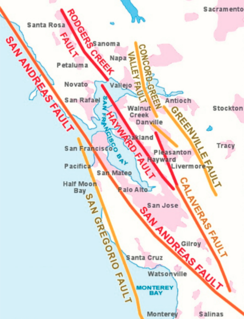
Plate tectonics drive fault motion, creating large fracture surfaces in the Earth’s crust as the plates move apart, alongside, or crash into each other. Along the San Andreas, this plate motion is primarily horizontal (side-to-side), as the Pacific plate moves North and the North American plate moves South.

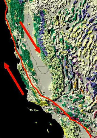
Major faults like the San Andreas are not actually one single fault, and instead make up fault zones, or networks of parallel faults that take up portions of the overall motion. Regional scale plate motion, like that responsible for the San Andreas, is often taken up by branching fault networks, instead of by one single fault zone. In the San Francisco Bay Area, the North-South motion of the Pacific and North American plate is taken up by four major faults: San Andreas, San Gregorio, Hayward, and Calaveras (right).

A careful look at the trace of the main San Andreas Fault reveals that this fault is not perfectly straight, but rather curves and wiggles a little bit. This complicates the motion of the fault. It is easy to slide two flat blocks past one another, but if you add bumps to these blocks, they are much harder to move. This is because when these bumps run into each other, they catch on one another. When these bumps are small (like sandpaper) it makes the fault hard to move. When these bumps are large, like the bend of the San Andreas Fault just north of Santa Cruz, the landscape in that bend can get squeezed together or pulled apart. Given the left-to-right motion of the San Andreas, the bend North of Santa Cruz squeezes the landscape together, thickening the crust and pushing the Earth upward to form the Santa Cruz Mountains.

The Faults in our Backyard

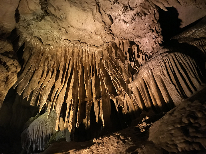
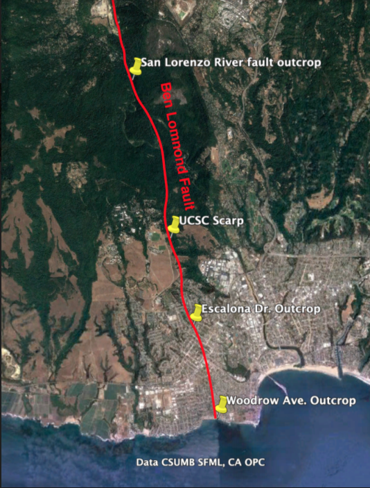
The Ben Lomond fault is the largest fault running through Santa Cruz, starting offshore in the Monterey Bay and weaving its way up into the Santa Cruz Mountains. Geologists know this fault was last active over 85,000 years ago, since it cuts through the older Purisima Sandstone and Santa Margarita Sandstone but does not disrupt the younger marine terrace deposits. The Ben Lomond fault is responsible for the path of the San Lorenzo river, which took advantage of rock that was fractured and weakened by motion along the fault.

Geologists from UCSC mapped the fault through Santa Cruz in the 1980’s, and for this installation of Rock Record we tracked the areas where this fault is visible from West Cliff drive up through Felton.

West Cliff Outcrop

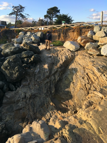
The Ben Lomond fault first outcrops (geologist jargon for becomes visible in rock) on West Cliff Dr. in Santa Cruz, at the end of Woodrow Avenue, just west of Mitchell’s Cove Beach. This outcrop is a subtle, tight notch in the cliff. When compared to other rocks along the sea cliff, the rocks in the Woodrow Ave. outcrop are much more fractured, which is a result of more intense rock deformation caused by motion along the fault. Note, the large, dark boulders along this section of the cliff were placed there to prevent erosion.


Escalona Dr. Outcrop

Because the Ben Lomond fault is younger than the marine rocks that make up most of Santa Cruz, evidence of its existence does not appear in many areas South of Felton. One exception is along Escalona Dr., where the fault creates a small notch in the north side of street on private property.


Fault Scarp on UCSC campus

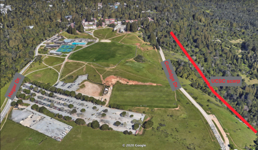
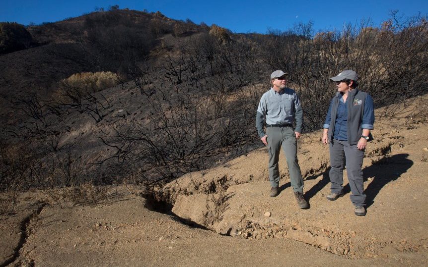
While an outcrop of the Ben Lomond fault is not visible between Escalona Dr. and Felton, evidence of motion along the fault can be seen along Coolidge Dr. on the UCSC campus. On the west side of the road, there is a steep drop down into Pogonip park. This ledge, termed a fault scarp, was made by motion along the Ben Lomond fault, where the east side of the fault was push upwards and the west side downwards. 


Outcrop Along the San Lorenzo in Henry Cowell State Park

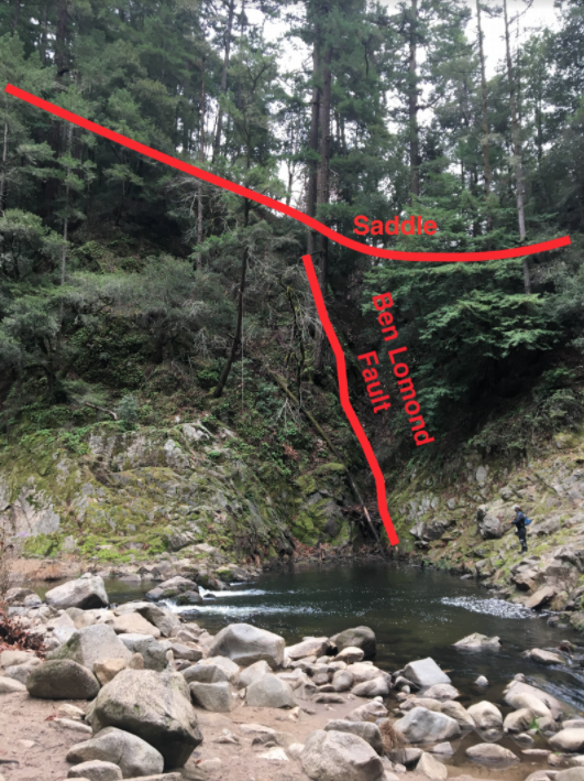
North of UCSC, the Ben Lomond fault runs parallel (and sometimes through) the San Lorenzo River. In Henry Cowell State park, just north of the “Garden of Eden” swimming hole, the Ben Lomond fault can be seen along the west bank of the river. While subtle, this outcrop has some of the tell-tale signs of fault activity. Similar to the West cliff outcrop, there is pronounced fracturing of the rock in this area. Additionally, topography on the west side of the river reaches a low-point, which geologists term a saddle, where the rocks are more eroded.

A Detour North: Año Nuevo Faults

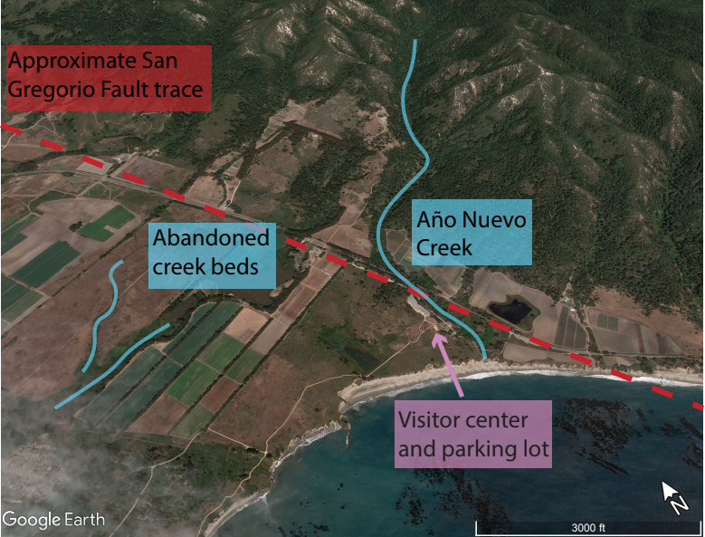
While the faults around Santa Cruz can be subtle or hard to get to, you don’t need to travel far to see faults and evidence of their activity. Año Nuevo State Park lies on the land where the trace of the San Gregorio Fault strikes dry land again (south of here it follows the coast just offshore). The San Gregorio Fault continues on its right-ward progress, dragging the westward/seaward portions of Año Nuevo to the northwest. Looking down at Año Nuevo State Park from the air, you can see the work of the San Gregorio Fault plainly. Año Nuevo Creek, which drains out of the steep mountains here, passes right by the visitor center and creates a pleasant, sheltered beach where it meets the ocean. However, over geologic history, the last leg of Año Nuevo Creek kept getting pushed to the northwest. Eventually it got pushed so far out of the way of upper Año Nuevo Creek, that the creek abandoned the distant creek bed and found a new, more convenient route. Geologists call this streambed hopping avulsion. But the abandoned creek beds to the northwest of today’s creek show us that the San Gregorio Fault has been shifting everything to the right of their neighbors across the fault. 

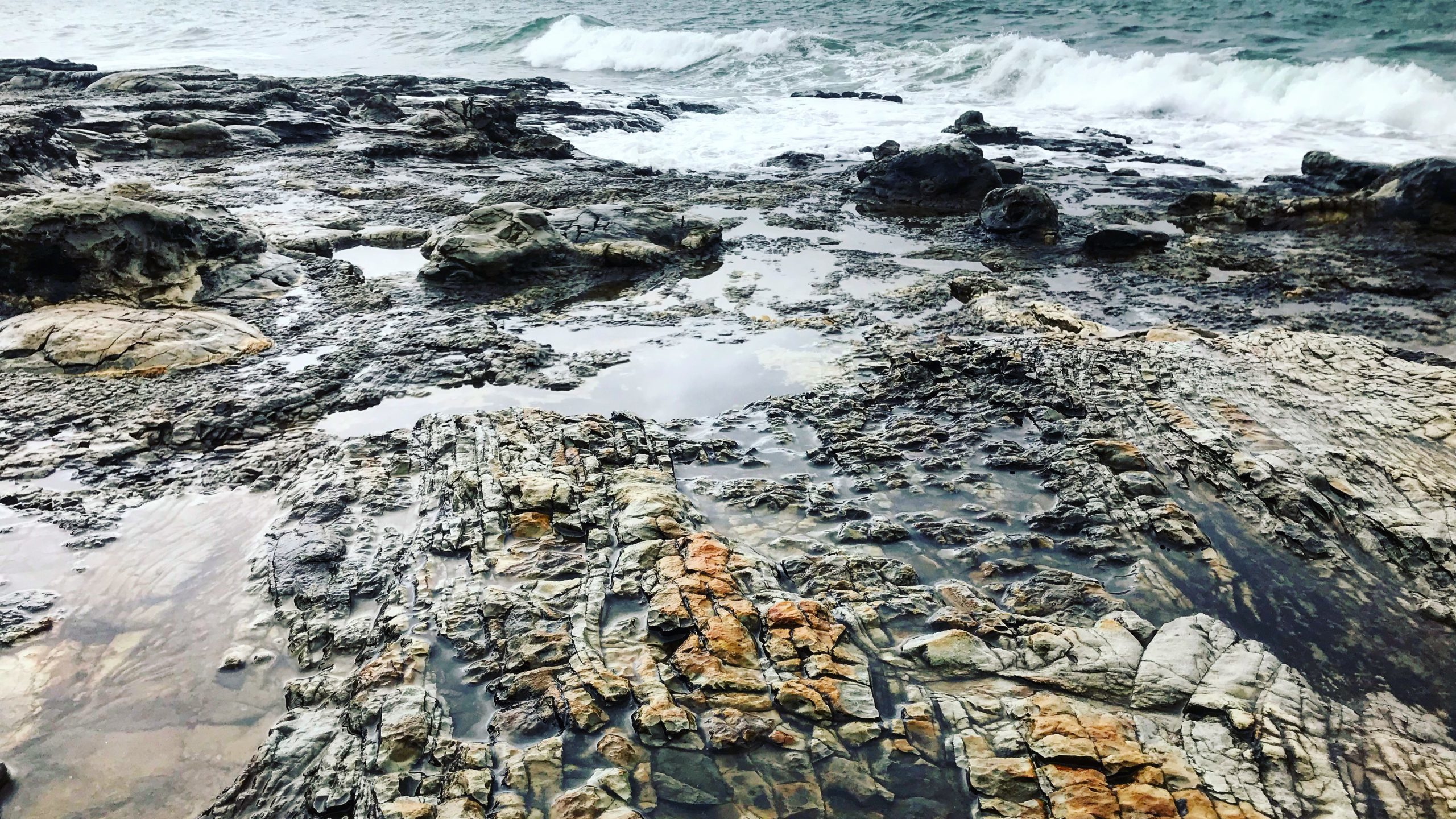
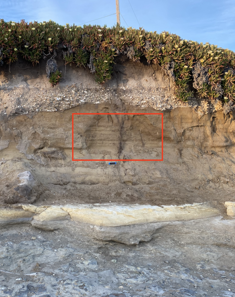
With the benefit of this birds’ eye view, let’s look a little bit closer and see what’s going on at human-scale. If you go from the visitor center (Marine Education Center) down along the Steele and New Years Creek Trails, you will arrive at the southern edge of Cove Beach, where Año Nuevo Creek reaches the ocean. If you continue southeast a short distance you come across a beautiful fault slicing across the sea cliff (below). This small little fault is not the San Gregorio Fault, but actually related to the nearby Año Nuevo Creek Fault which slices up the valley the creek flows down. As faults damage the rocks they cut through, they weaken the rock there, making it easy prey for an erosive mountain stream to chew into.

First creek fault.

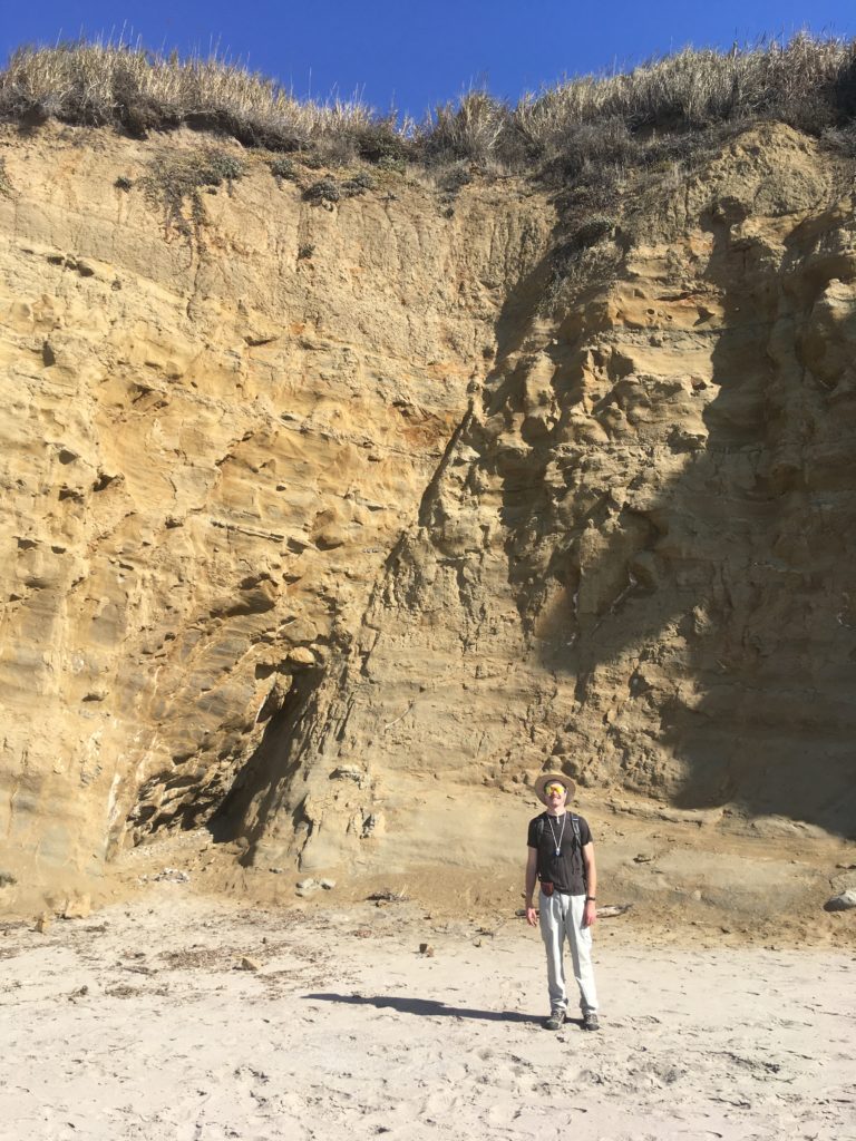
We can even do a little geologic sleuthing. The fault clearly slices through the ancient sandy beach deposits on the top of the cliff, so we know the fault must be younger than those. Those sandy deposits are less than 100,000 years old, so we know this fault has moved in the last 100,000 years.

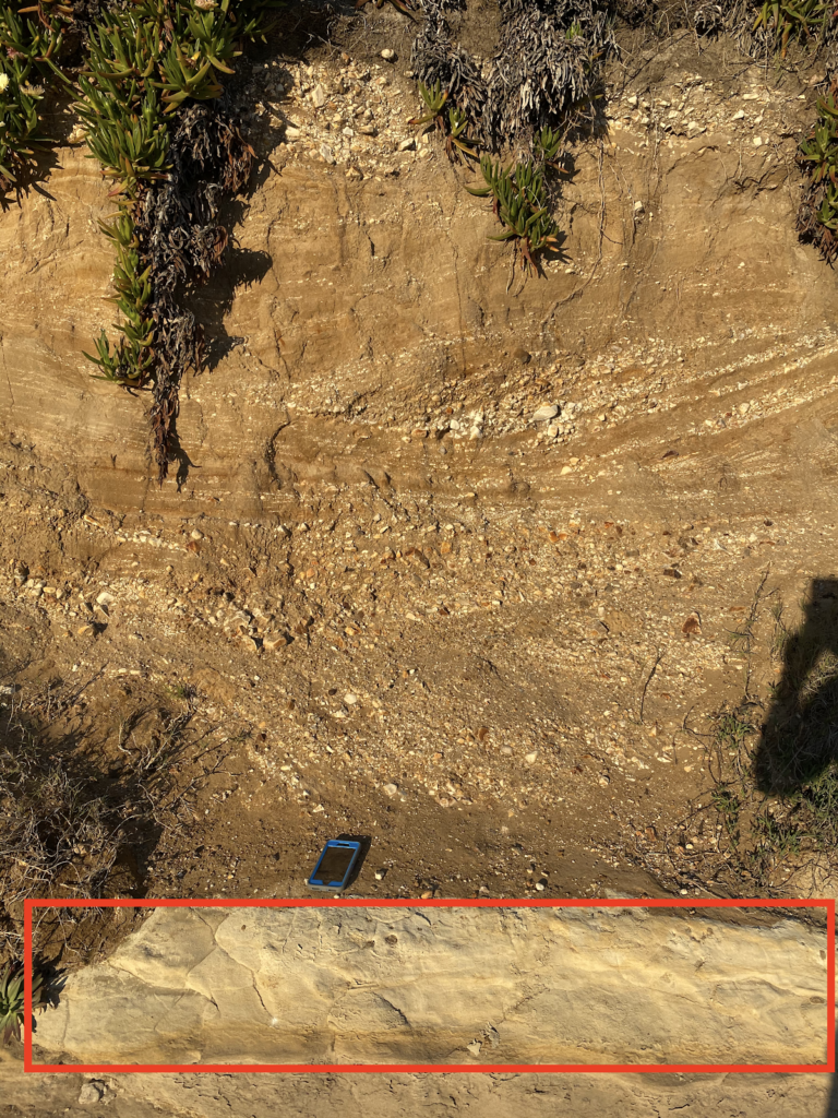
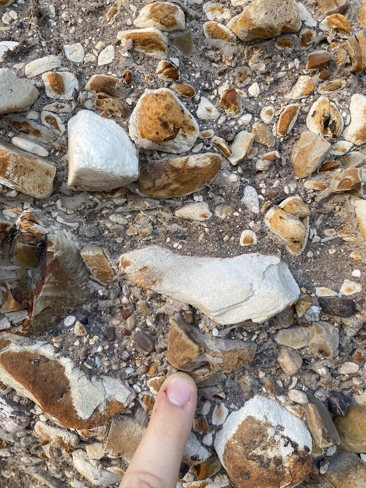
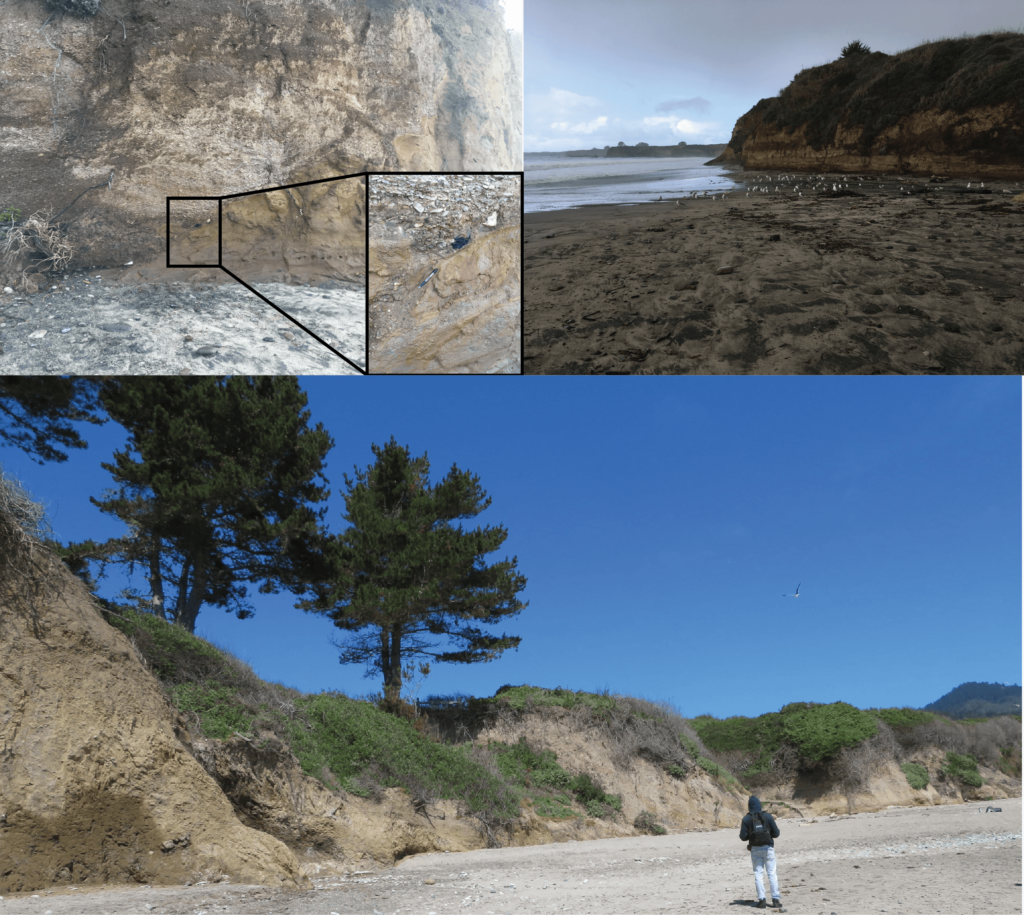
Let’s return to the creek, and look southeast toward Santa Cruz. Here you can see two different rocks pressed together There are light-colored pebbly rocks that meet with the familiar brown sandstone of the Purisima Formation along a jagged, sloping line of contact. The zig-zags of the contact are old stream banks where the ancient creek chewed into the rocky bank. Those pebbly rocks above the old stream banks are ancient deposits of Año Nuevo Creek. This means that today the Creek is now eroding back into them! If we get up close to the rocks, we can even find a variety of rocks including some charcoal that came from ancient fires and was washed away with rainwater before getting caught up in these streambank deposits. 

Some of these chunks of charcoal have been dated using radiocarbon and give an age of around 10 thousand years old (unpublished data from this report). Since these deposits have 10,000 year old charcoal in them, they cannot be any older than 10,000 years. That is super young in geologic terms.

If we travel to the northwest toward Pescadero on Cove Beach we can follow these young creek deposits on the cliff and even see a few faults that cut through the rocks of the cliffs. As you come level with the “Pond” a few trees tower at the edge of the cliff. If you look closely here, you can see that the light pebbles fade into a messy zone of jumbled rock and eventually back into familiar Purisima sandstones. That messy zone of jumbled rock is none other than the Frijoles Fault. Since this fault slices through those 10,000 year old stream deposits, the fault must be younger than 10,000 years. Once again, in geologic terms, this is a young and active fault.

The sea cliffs along Cove Beach are a great place to do geologic detective work. Just remember that these sea cliffs are zones of active erosion and rockfalls may happen unexpectedly. When looking at rocky cliffs, always be careful, aware, and safe!


Rock Record is a monthly blog featuring musings on the mineral world from Gavin Piccione and Graham Edwards.

Graham Edwards and Gavin Piccione are PhD candidates in geochronology with the Department of Earth and Planetary Sciences at UC Santa Cruz. They also host our monthly Rockin’ Pop-Ups as “The Geology Gents”.

Rockin’ Pop-Up: The Varieties of Volcanoes

This month, the Geology Gents explore how varied volcanoes can be. Graham Edwards and Gavin Piccione, PhD candidates in geochronology at UC Santa Cruz, put on blast how lava type affects the appearance of volcanoes and the way those volcanoes erupt.

About the Series: Join the Geology Gents, Gavin and Graham, for monthly conversations about rocks live on Facebook. Each month we’ll explore a different geologic topic, from Santa Cruz formations to tips for being a more effective rockhound. Graham Edwards and Gavin Piccione are PhD candidates in geochronology with the Department of Earth and Planetary Sciences at UC Santa Cruz.

Submit your questions ahead of time by emailing events@santacruzmuseum.org and feel free to include pictures of rocks you’d like identified! Note: you do not need to have a Facebook account to be able to watch the program live.

Watch Past Pop-Ups
Read our blog Rock Record

Rockin’ Pop-Up: Paleoclimatology

This month, the Geology Gents explore what has happened to the Earth throughout its history when sudden climate change has occurred. Hint: it usually involves mass extinctions. Look back at last month’s episode exploring Ice Ages as a primer for this discussion of paleoclimatology, or the study of ancient climates.

About the Series: Join the Geology Gents, Gavin and Graham, for monthly conversations about rocks live on Facebook. Each month we’ll explore a different geologic topic, from Santa Cruz formations to tips for being a more effective rockhound. Graham Edwards and Gavin Piccione are PhD candidates in geochronology with the Department of Earth and Planetary Sciences at UC Santa Cruz.

Submit your questions ahead of time by emailing events@santacruzmuseum.org and feel free to include pictures of rocks you’d like identified! Pro-tip: the better the picture, the better the ID.

Watch Past Pop-Ups
Read our blog Rock Record

Rock Record: Guide to the Swift Street Outcrop

By Graham Edwards and Gavin Piccione (aka the Geology Gents)

Santa Cruz is an ideal place to explore marine and coastal geology, with millions of years worth of geologic history exposed along its sea cliffs. One of the Gent’s favorite outcrops in Santa Cruz is along the cliff face on West Cliff Drive, at the end of Swift Street.


Getting to the outcrop

Park at the end of Swift Street and cross West Cliff Drive. Take one of the paths through the ice plant and walk down onto the coastal platform. Be careful, in some areas the path down to the outcrop can be steep.

To find the Swift outcrop on a map, the latitude and longitude are:
36˚56’58.72” N
122˚02’49.22” W

Download our West Cliff Rock Walk guide to help you get there!


A guide to the rock formations

The Swift Street outcrop contains over 9 million years worth of geologic history of the coast of Santa Cruz. Familiar formations found at Swift Street include the Purisima sandstone and the Santa Cruz mudstone, along with younger beach deposits that make up the top layer of the outcrop (pictured right). Each of these layers are separated by sharp erosional contacts (geologists call these disconformities) that represent missing time and material in the rock record.

Watch our Rockin’ Pop-Up on Santa Cruz Formations.


Ancient Methane seeps within the Santa Cruz mudstone

The bulbous, light-colored features found at and near the Swift Street outcrop are the geologic remnants of methane seeps, also known as “cold seeps” (pictured below).

Bulbous fossilized “cold seeps” at the Swift Street outcrop.

These formed while the Santa Cruz Mudstone was still mud in deep waters off the coast of California between 7-9 million years ago. The rock accumulated as sediments, including the bodies of perished sea critters, fell to the sea floor. As the bodies of phytoplankton and other marine microorganisms decayed in this mud, they released gases that slowly worked their way up to the surface. As these gasses followed cracks in the firmly packed sediment, they gradually widened these conduits and cemented the walls with carbonate minerals (the same thing limestone, chalk, and marble are made of), creating a sort of chimney to release these gases and fluids out of the seafloor.

Diagram of how the fluids and methane seeped their way from deep below the seafloor up through mudstones like the Santa Cruz mudstone. The original research on these fossilized methane seeps was done by UC Santa Cruz researchers and students! (Image source: http://citeseerx.ist.psu.edu/viewdoc/download?doi=10.1.1.151.216&rep=rep1&type=pdf)

Seeps like these that bring methane gas and fluids from deep below the seafloor can be found today out in the deep regions of Monterey Bay. In millions of years from now, these same chimneys may find themselves on a new coastal outcrop!

Seafloor methane seeps like the ones preserved at Swift Street occur in the Monterey Submarine Canyon today, providing nutrients for mini ecosystems on the seafloor, like these red-orange microbes that form mats around the seeps. (Image from the Monterey Bay Aquarium Research Institute)

Layers of the Santa Cruz Mudstone

While the fossilized cold seeps tend to get a lot of the attention, the tough Santa Cruz Mudstone around them is itself a fascinating piece of rock. In this area, the Santa Cruz Mudstone hosts alternating layers of pale mud and blocky porcellanite (pictured right), a rock that gets its name from its close resemblance to unglazed porcelain. This rock is very similar to chert, a glassy rock formed at the seafloor from the accumulation of the glassy skeletons of diatoms. Porcellanite, like that found at the Swift Street outcrop, has a bit more clay and calcite (probably from critters that make chalky skeletons) giving it its more porcelain-like appearance.

The layers of porcellanites have a distinctively blocky texture. This results from the very brittle nature of the rock type. Just like pieces of porcelain, when these were squeezed and warped by tectonic pressure, rather than bending like the softer, more ductile mud layers, the porcellanite essentially shattered in response to those forces. Yet, even in its shattered state, the porcelanite rock is remarkably strong and durable. For this reason, Santa Cruz Mudstone with its rugged porcellanite layers makes up many of the flat bases of the sea cliffs around West Cliff as it stands up against the erosive force of the waves that more easily cuts into the sands and sandstones of the overlying cliffs.

The highest visible layer of the Santa Cruz Mudstone is a thick (almost 1 foot-thick) light-colored mud layer (pictured left), that has old clam burrows on its surface and is overlain by Purisima formation with large chunks of porcellanite from the mudstones below. This tells us that before the sands of the Purisima Formation were laid down atop the mudstone, it spent some time being eroded by waves. Those clam burrows are a testament to the time it spent as a rocky seafloor bottom over 6 million years ago.

The chunks of porcellanite just above the contact tell the story of the earliest history of the Purisima Formation as powerful waves broke down and churned up rocks that were incorporated into the first layers of the Purisima sands.


The Purisima Sandstone Formation

Above the Santa Cruz mudstone lies the Purisima sandstone, a rock formation known throughout Santa Cruz for its abundance of stark white fossils of ancient shells. Swift Street contains only a relatively small section of the Purisima Formation, but several areas within it exhibit amazing sedimentary textures. Up on the cliff, sections of the Purisima are a flat brown, with no visible fossils, and parallel “beds” or ancient sediment layers (pictured right). These areas represent long periods of constant sediment deposition, with no major storms or changes to the environment.

Elsewhere in the outcrop, shell-rich layers and features called “cross-beds” (pictured below) tell us that at other times between 7 and 2.6Ma, this area experienced large storms that created strong ocean currents. The jagged contact between the Purisima formation and the above Quaternary-aged sediments represents nearly two million years of lost time in the rock record. 


Erosion and deposition of sands on top in the last 100,000 years

The base of the uppermost layer of the Swift Street outcrop is made up of an unconsolidated matrix of fine sand surrounding large, cobble-sized pieces of the underlying sedimentary rocks (pictured right), as well as abundant shell fragments. Because this layer is made up of fairly loose sediments, as opposed to rock, we know that it has not experienced long periods of burial required to turn sediment into rock (or lithification in geologist jargon.) For large cobbles to be ripped-up from the underlying layers and deposited here, requires high-energy wave systems like those found on the modern coast. Therefore, the transition from the underlying Purisima sandstone to these sediments likely represents a time where the Santa Cruz coast shifted from deep water to a coastal zone, likely as a result of sea level fall and tectonic uplift. 


Rock Record is a monthly blog featuring musings on the mineral world from Gavin Piccione and Graham Edwards.

Graham Edwards and Gavin Piccione are PhD candidates in geochronology with the Department of Earth and Planetary Sciences at UC Santa Cruz. They also host our monthly Rockin’ Pop-Ups as “The Geology Gents”.

Fire and Mud: Why Fires Cause Debris Flows in California with Noah Finnegan

Geomorphologist Noah Finnegan provides an overview of the science linking wildfires and debris flows in California, including lessons learned from the 2009 Lockheed Fire in the Santa Cruz mountains. Particular emphasis is paid to how residents impacted by the CZU Lightning Complex can navigate resources to better understand their debris-flow risks.

Resources

Below are resources referred to in the presentation and major take-aways from Noah Finnegan:

About the Speaker

Noah Finnegan is a professor in Earth and Planetary Sciences at UC Santa Cruz. Noah’s research and teaching are focused on processes of erosion and sediment transport on hill slopes and in river channels.

Rockin’ Pop-Up: Supercontinents

An illustration that shows the continents in different positions on a circle representing the earth. To the right is text and images of two men.

There have been a dozen major and minor supercontinents over the earth’s 4.567 billion year history, and odds are that there will be more. Explore plate tectonics and continental drift in this month’s Rockin’ Pop-Up.

About the Series: Join the Geology Gents, Gavin and Graham, for monthly conversations about rocks live on Facebook. Each month we’ll explore a different geologic topic, from Santa Cruz formations to tips for being a more effective rockhound. Graham Edwards and Gavin Piccione are PhD candidates in geochronology with the Department of Earth and Planetary Sciences at UC Santa Cruz.

Submit your questions ahead of time by emailing events@santacruzmuseum.org and feel free to include pictures of rocks you’d like identified! Pro-tip: the better the picture, the better the ID.

Watch Past Pop-Ups
Read our blog Rock Record

Rockin’ Pop-Up: Caves (Special Edition)

Photo of stalactite formations in a marble cave.

In honor of Halloween, we’re exploring the curious, the scary, and the strange all week during our series, Museum of the Macabre. And what’s scarier than a deep, dark cave? For the special Halloween Pop-Up, Gavin and Graham will explore the different ways that caves form. Learn more about caves in this month’s Rock Record blog post.

About the Series: Join the Geology Gents, Gavin and Graham, for monthly conversations about rocks live on Facebook. Each month we’ll explore a different geologic topic, from Santa Cruz formations to tips for being a more effective rockhound. Graham Edwards and Gavin Piccione are PhD candidates in geochronology with the Department of Earth and Planetary Sciences at UC Santa Cruz.

Submit your questions ahead of time by emailing events@santacruzmuseum.org and feel free to include pictures of rocks you’d like identified! Pro-tip: the better the picture, the better the ID.

Watch Past Pop-Ups
Read our blog Rock Record

Rockin’ Pop-Up: Building Appalachia

The mountain ranges along our western edge of North America have a much different origin story than those of the east coast. We’ve explored the Sierra and the Santa Cruz Mountains in past pop-ups. This time around we’re comparing our relatively young ranges to the ancient origins of the Appalachians and beyond.

About the Series: Join the Geology Gents, Gavin and Graham, for monthly conversations about rocks live on Facebook. Each week we’ll explore a different geologic topic, from Santa Cruz formations to tips for being a more effective rockhound. Graham Edwards and Gavin Piccione are PhD candidates in geochronology with the Department of Earth and Planetary Sciences at UC Santa Cruz.

Submit your questions ahead of time here or by email to events@santacruzmuseum.org and feel free to include pictures of rocks you’d like identified! Pro-tip: the better the picture, the better the ID.

Watch Past Pop-Ups

Collections Close-Up: Santa Cruz Fossils and the People Who Dig ‘Em

Frank Perry works on a cast of a fossil sea cow skeleton.

Dig into the fossil record of Santa Cruz through the eyes of locals who find themselves captivated by these windows into the past and who made it their work to share this passion with others. One of these important contributors, Wayne Thompson, will share his history with the Museum and the unique potential that fossils have to engage students with science and the natural world, inspiring the next generation of environmental stewards.

About the series: Zoom into the stories, secrets, and science of our collections during monthly webinars with Collections Manager Kathleen Aston. This live event is an extension of our monthly Collections Close-Up blog, with added insights and intrigue. Members are invited to participate in this program before it is made available to the general public as well as ask questions directly of Kathleen. Watch last month’s webinar on preservation policies in Museum collections.

Not yet a Member? Join today!

Rockin’ Pop-Up: Impacts of Fire on Geologic Landscapes

This month, the Geology Gents are joined by their colleague Alandra Lopez, a Ph.D. candidate in the Earth System Science Department at Stanford University who will discuss the impacts of fire on geologic systems, as well as spend some time on one of our state’s unique features: serpentine soils.

Alandra studies the biogeochemical processes that control the release of naturally occurring contaminants, like arsenic, uranium, and hexavalent chromium, in soils to groundwater.

About the Series: Join the Geology Gents, Gavin and Graham, for monthly conversations about rocks live on Facebook. Each week we’ll explore a different geologic topic, from Santa Cruz formations to tips for being a more effective rockhound. Graham Edwards and Gavin Piccione are PhD candidates in geochronology with the Department of Earth and Planetary Sciences at UC Santa Cruz.

Submit your questions ahead of time here or by email to events@santacruzmuseum.org and feel free to include pictures of rocks you’d like identified! Pro-tip: the better the picture, the better the ID.

Watch Past Pop-Ups