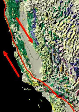
In this installation of Rock Record, we explore how faults shape Santa Cruz. First, a little about faults.
By Graham Edwards and Gavin Piccione (aka the Geology Gents)
Image: San Andreas Fault. Credit: Kate Borton, David Howell, and Joe Vigil.
Faults are flat fracture surfaces within rock where portions of the rock move past each other. These features are some of the most prominent ways geologic processes shape the surface of the Earth. Motion along faults is responsible for the creation of most of the Earth’s mountains and valleys; faults significantly impact how and where rocks are eroded; and motion across faults causes earthquakes. In California, the most iconic fault is the continent-scale San Andreas Fault, but faults in this area occur at a wide range of sizes and often create familiar landscape features.
The Creation of the Santa Cruz Mountains
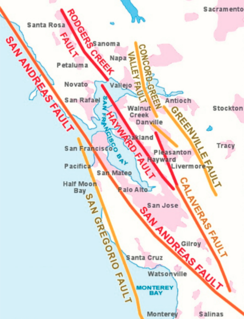
Plate tectonics drive fault motion, creating large fracture surfaces in the Earth’s crust as the plates move apart, alongside, or crash into each other. Along the San Andreas, this plate motion is primarily horizontal (side-to-side), as the Pacific plate moves North and the North American plate moves South.
Major faults like the San Andreas are not actually one single fault, and instead make up fault zones, or networks of parallel faults that take up portions of the overall motion. Regional scale plate motion, like that responsible for the San Andreas, is often taken up by branching fault networks, instead of by one single fault zone. In the San Francisco Bay Area, the North-South motion of the Pacific and North American plate is taken up by four major faults: San Andreas, San Gregorio, Hayward, and Calaveras (right).
A careful look at the trace of the main San Andreas Fault reveals that this fault is not perfectly straight, but rather curves and wiggles a little bit. This complicates the motion of the fault. It is easy to slide two flat blocks past one another, but if you add bumps to these blocks, they are much harder to move. This is because when these bumps run into each other, they catch on one another. When these bumps are small (like sandpaper) it makes the fault hard to move. When these bumps are large, like the bend of the San Andreas Fault just north of Santa Cruz, the landscape in that bend can get squeezed together or pulled apart. Given the left-to-right motion of the San Andreas, the bend North of Santa Cruz squeezes the landscape together, thickening the crust and pushing the Earth upward to form the Santa Cruz Mountains.
The Faults in our Backyard
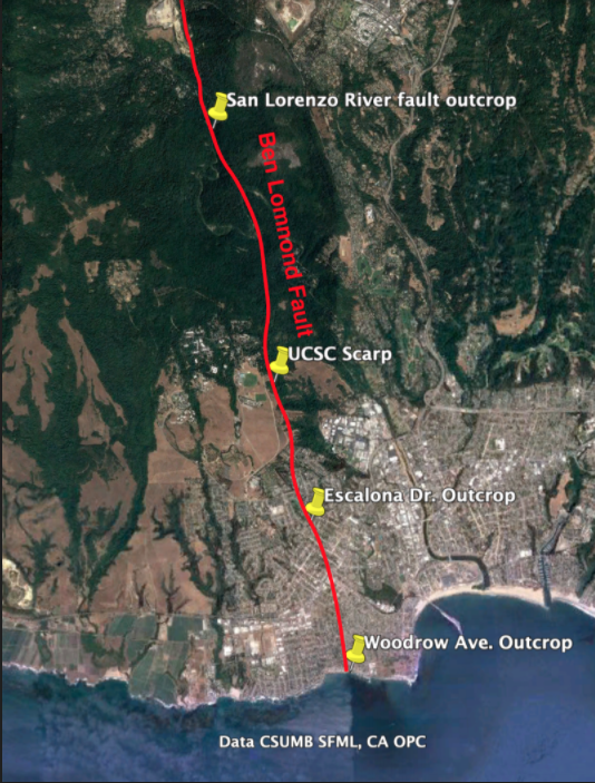
The Ben Lomond fault is the largest fault running through Santa Cruz, starting offshore in the Monterey Bay and weaving its way up into the Santa Cruz Mountains. Geologists know this fault was last active over 85,000 years ago, since it cuts through the older Purisima Sandstone and Santa Margarita Sandstone but does not disrupt the younger marine terrace deposits. The Ben Lomond fault is responsible for the path of the San Lorenzo river, which took advantage of rock that was fractured and weakened by motion along the fault.
Geologists from UCSC mapped the fault through Santa Cruz in the 1980’s, and for this installation of Rock Record we tracked the areas where this fault is visible from West Cliff drive up through Felton.
West Cliff Outcrop

The Ben Lomond fault first outcrops (geologist jargon for becomes visible in rock) on West Cliff Dr. in Santa Cruz, at the end of Woodrow Avenue, just west of Mitchell’s Cove Beach. This outcrop is a subtle, tight notch in the cliff. When compared to other rocks along the sea cliff, the rocks in the Woodrow Ave. outcrop are much more fractured, which is a result of more intense rock deformation caused by motion along the fault. Note, the large, dark boulders along this section of the cliff were placed there to prevent erosion.
Escalona Dr. Outcrop
Because the Ben Lomond fault is younger than the marine rocks that make up most of Santa Cruz, evidence of its existence does not appear in many areas South of Felton. One exception is along Escalona Dr., where the fault creates a small notch in the north side of street on private property.
Fault Scarp on UCSC campus
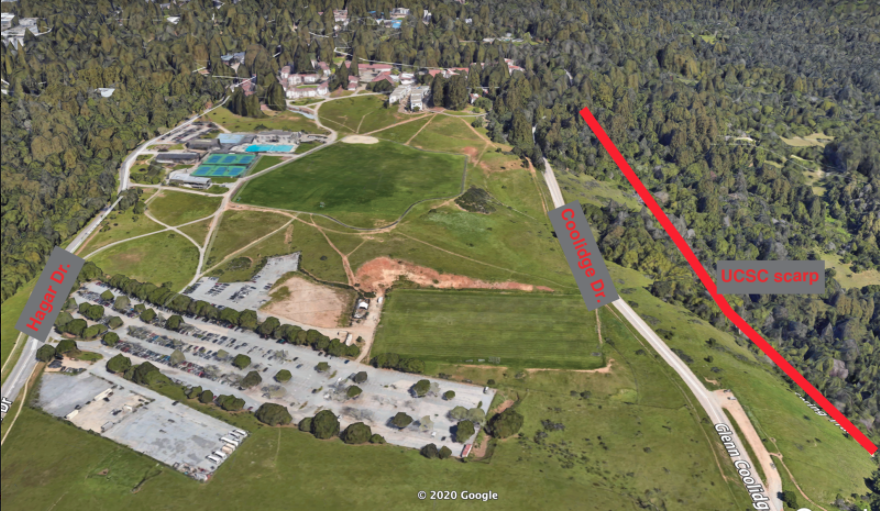
While an outcrop of the Ben Lomond fault is not visible between Escalona Dr. and Felton, evidence of motion along the fault can be seen along Coolidge Dr. on the UCSC campus. On the west side of the road, there is a steep drop down into Pogonip park. This ledge, termed a fault scarp, was made by motion along the Ben Lomond fault, where the east side of the fault was push upwards and the west side downwards.
Outcrop Along the San Lorenzo in Henry Cowell State Park
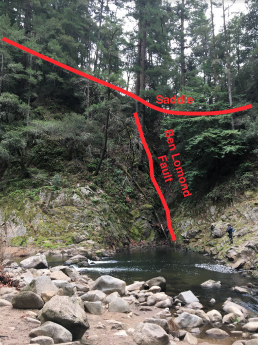
North of UCSC, the Ben Lomond fault runs parallel (and sometimes through) the San Lorenzo River. In Henry Cowell State park, just north of the “Garden of Eden” swimming hole, the Ben Lomond fault can be seen along the west bank of the river. While subtle, this outcrop has some of the tell-tale signs of fault activity. Similar to the West cliff outcrop, there is pronounced fracturing of the rock in this area. Additionally, topography on the west side of the river reaches a low-point, which geologists term a saddle, where the rocks are more eroded.
A Detour North: Año Nuevo Faults
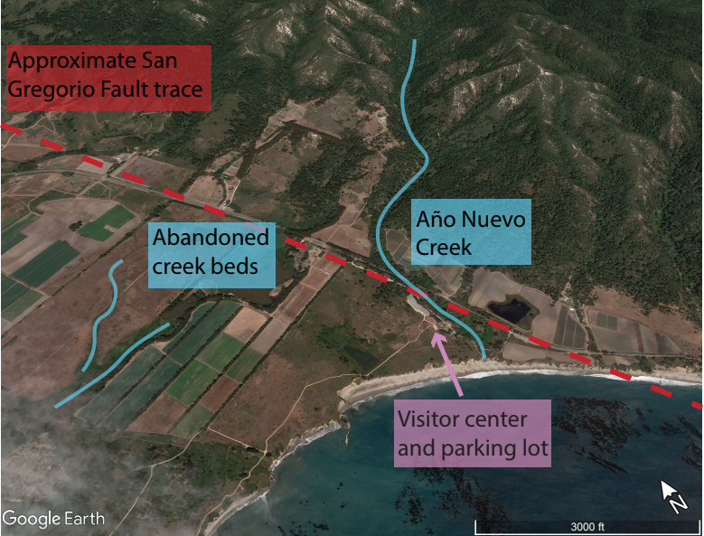
While the faults around Santa Cruz can be subtle or hard to get to, you don’t need to travel far to see faults and evidence of their activity. Año Nuevo State Park lies on the land where the trace of the San Gregorio Fault strikes dry land again (south of here it follows the coast just offshore). The San Gregorio Fault continues on its right-ward progress, dragging the westward/seaward portions of Año Nuevo to the northwest. Looking down at Año Nuevo State Park from the air, you can see the work of the San Gregorio Fault plainly. Año Nuevo Creek, which drains out of the steep mountains here, passes right by the visitor center and creates a pleasant, sheltered beach where it meets the ocean. However, over geologic history, the last leg of Año Nuevo Creek kept getting pushed to the northwest. Eventually it got pushed so far out of the way of upper Año Nuevo Creek, that the creek abandoned the distant creek bed and found a new, more convenient route. Geologists call this streambed hopping avulsion. But the abandoned creek beds to the northwest of today’s creek show us that the San Gregorio Fault has been shifting everything to the right of their neighbors across the fault.
With the benefit of this birds’ eye view, let’s look a little bit closer and see what’s going on at human-scale. If you go from the visitor center (Marine Education Center) down along the Steele and New Years Creek Trails, you will arrive at the southern edge of Cove Beach, where Año Nuevo Creek reaches the ocean. If you continue southeast a short distance you come across a beautiful fault slicing across the sea cliff (below). This small little fault is not the San Gregorio Fault, but actually related to the nearby Año Nuevo Creek Fault which slices up the valley the creek flows down. As faults damage the rocks they cut through, they weaken the rock there, making it easy prey for an erosive mountain stream to chew into.
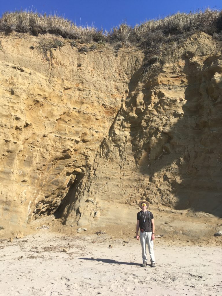
We can even do a little geologic sleuthing. The fault clearly slices through the ancient sandy beach deposits on the top of the cliff, so we know the fault must be younger than those. Those sandy deposits are less than 100,000 years old, so we know this fault has moved in the last 100,000 years.
Let’s return to the creek, and look southeast toward Santa Cruz. Here you can see two different rocks pressed together There are light-colored pebbly rocks that meet with the familiar brown sandstone of the Purisima Formation along a jagged, sloping line of contact. The zig-zags of the contact are old stream banks where the ancient creek chewed into the rocky bank. Those pebbly rocks above the old stream banks are ancient deposits of Año Nuevo Creek. This means that today the Creek is now eroding back into them! If we get up close to the rocks, we can even find a variety of rocks including some charcoal that came from ancient fires and was washed away with rainwater before getting caught up in these streambank deposits.
Some of these chunks of charcoal have been dated using radiocarbon and give an age of around 10 thousand years old (unpublished data from this report). Since these deposits have 10,000 year old charcoal in them, they cannot be any older than 10,000 years. That is super young in geologic terms.
If we travel to the northwest toward Pescadero on Cove Beach we can follow these young creek deposits on the cliff and even see a few faults that cut through the rocks of the cliffs. As you come level with the “Pond” a few trees tower at the edge of the cliff. If you look closely here, you can see that the light pebbles fade into a messy zone of jumbled rock and eventually back into familiar Purisima sandstones. That messy zone of jumbled rock is none other than the Frijoles Fault. Since this fault slices through those 10,000 year old stream deposits, the fault must be younger than 10,000 years. Once again, in geologic terms, this is a young and active fault.
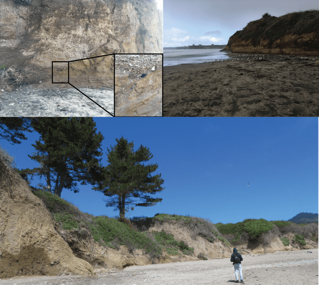
The sea cliffs along Cove Beach are a great place to do geologic detective work. Just remember that these sea cliffs are zones of active erosion and rockfalls may happen unexpectedly. When looking at rocky cliffs, always be careful, aware, and safe!
Rock Record is a monthly blog featuring musings on the mineral world from Gavin Piccione and Graham Edwards.
Graham Edwards and Gavin Piccione are PhD candidates in geochronology with the Department of Earth and Planetary Sciences at UC Santa Cruz. They also host our monthly Rockin’ Pop-Ups as “The Geology Gents”.
