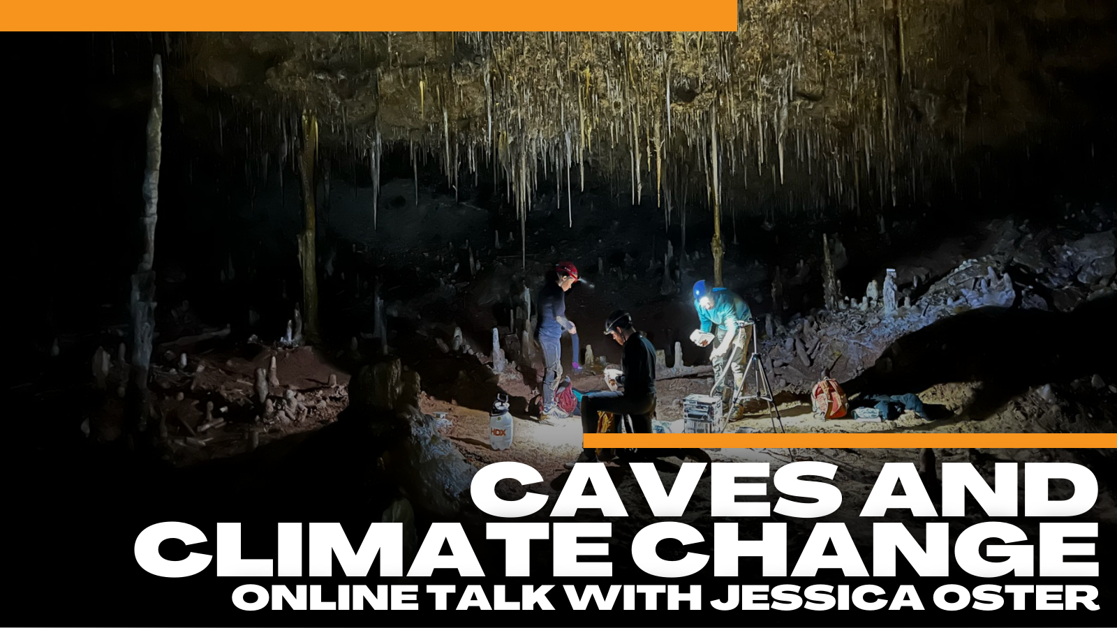
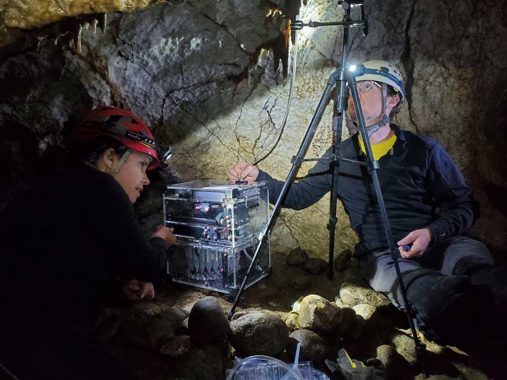
The Santa Cruz Mountains are full of limestone caves that hold many secrets, including records of our climate past. Join Dr. Jessica Oster for an exploration into White Moon Cave where she researches stalagmites (mineral formations growing up from cave floors) that record the climate and environment above the cave as they grow. One stalagmite from White Moon Cave has revealed linkages between the plant community and fire activity above the cave and “climate whiplash” or oscillations between extreme wet and dry periods that occurred over 8,000 years ago. We will discuss how climate records from stalagmites are created as well as the unique things we have learned about California climate from Santa Cruz Mountains caves.
Jessica Oster is an Associate Professor of Earth and Environmental Sciences at Vanderbilt University in Nashville, TN. She completed her PhD at the University of California, Davis. Oster studies chemical variations in cave mineral formations such as stalagmites to reconstruct climate change in the past, including changes in rainfall, vegetation, and fire activity above the cave. She has developed stalagmite-based records of climate change from caves in northern and central California, Wyoming, Tennessee, India, and the island of Curaçao.
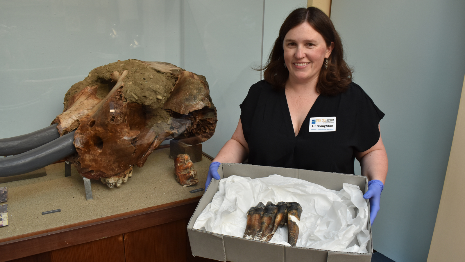
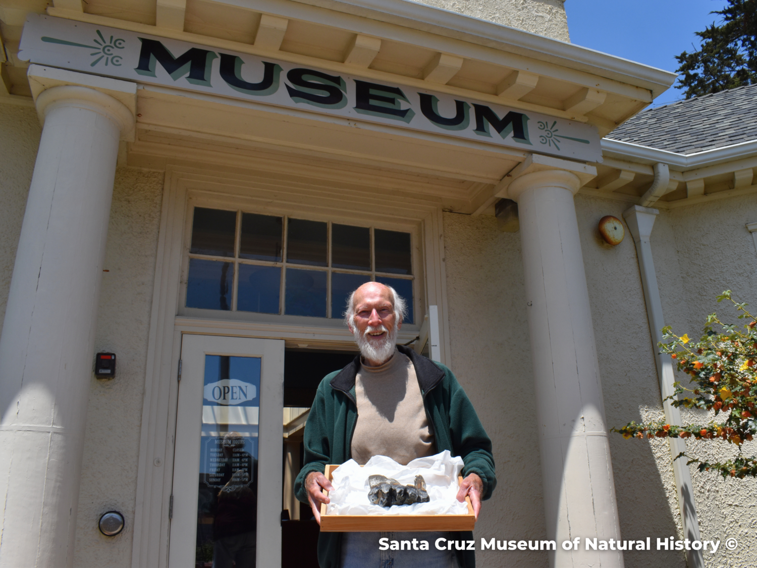
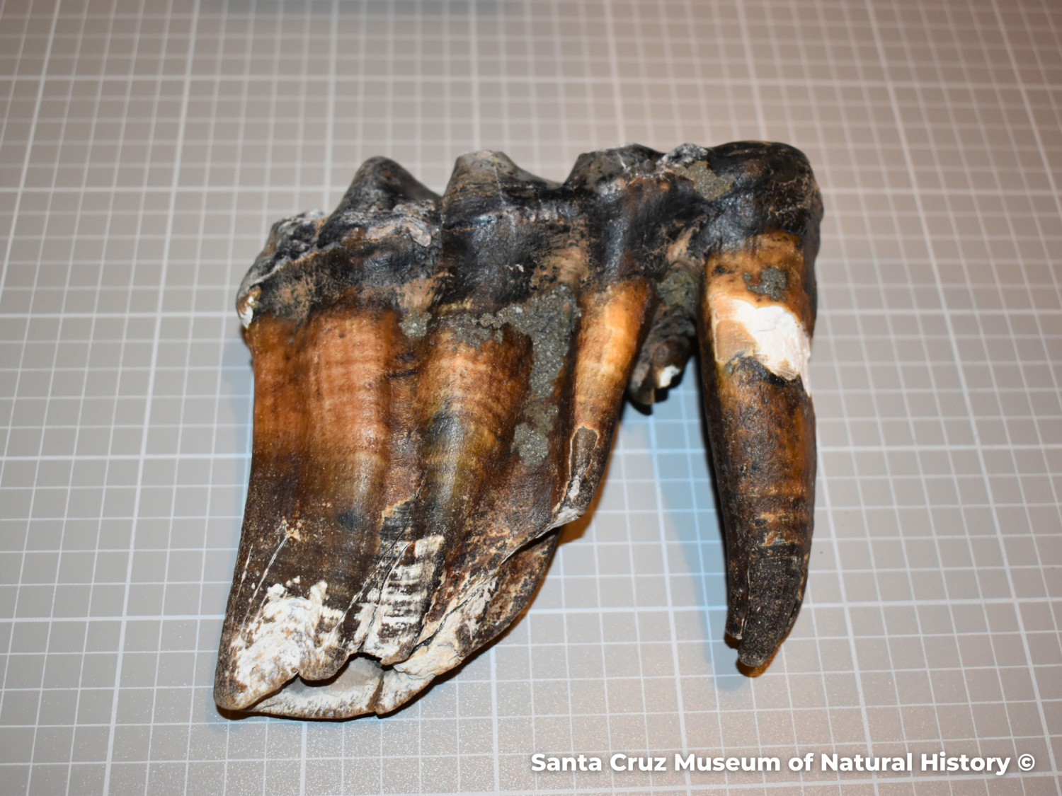
A very special tooth in Santa Cruz County has captured the attention of the world. A widespread community campaign to recover a mastodon tooth that went missing after being recorded on a local beach culminated on May 30, 2023 when Jim Smith brought a special treasure to the Santa Cruz Museum of Natural History.
Here’s How the Story Unfolded
As Memorial Day weekend ramped up in Santa Cruz County, a tourist with ties to the area spotted an unusual object on Rio Del Mar beach. Uncertain of what she was seeing, she photographed her unusual find and shared it on social media in the hopes that it would be identified. That’s when Santa Cruz Museum of Natural History Paleontology Collections Advisor, Wayne Thompson, posted online to clarify the significance of the discovery.
“This is (a) … molar tooth of the Pacific Mastodon Mammut pacificus, and an extremely important find. Give me a call when you get a chance…” Thompson wrote in response to the post.
When Thompson arrived at the location where the tooth was originally discovered, it was gone. A public call to find the tooth went out across multiple platforms, with local and international news outlets joining the Museum’s efforts to recover and protect the important specimen. On the morning of May 30, Jim Smith, a local man who had seen the news about the tooth, called the Museum.
“I was so excited to get that call,” said Liz Broughton, Visitor Experience Manager at the Museum. “Jim told us that he had stumbled upon it during one of his regular jogs along the beach, but wasn’t sure of what he had found until he saw a picture of the tooth on the news. He was so excited to hear it was a mastodon tooth and was eager to share it with the Museum.”
Mastodons in Santa Cruz County
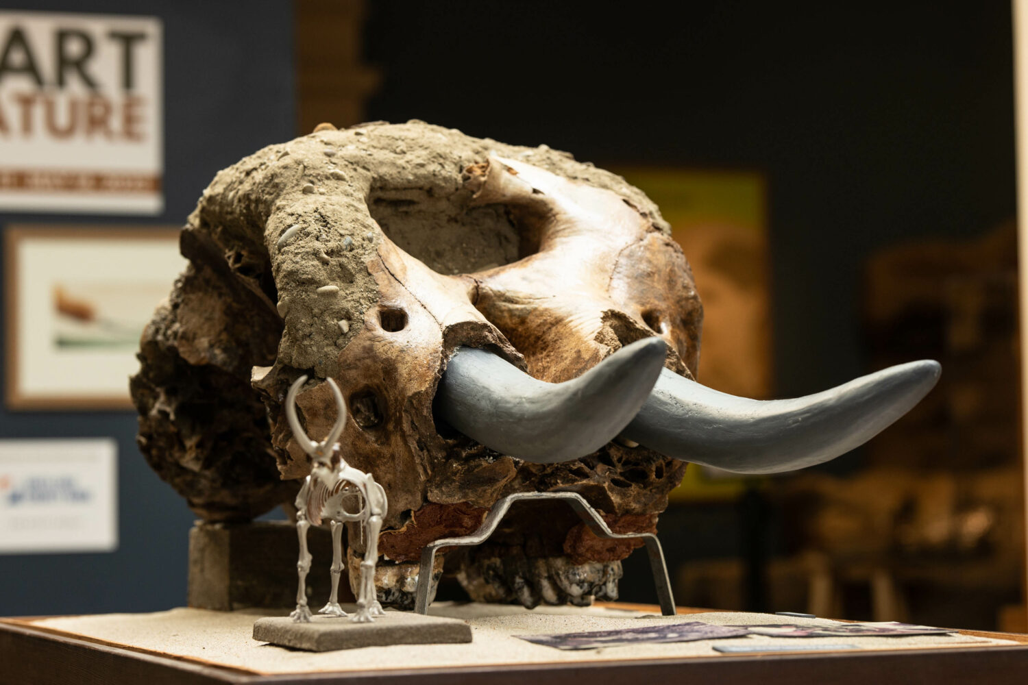
The Museum has a long history with local mastodons. In 1980, 16-year-old Jim Stanton found a mastodon skull in Aptos Creek, which Thompson excavated and spent years meticulously repairing. Visitors can explore this skull, the only other locally recorded specimen, at the Museum of Natural History where it is on permanent exhibit.
Thompson first came to the Museum in 1976 as a high school sophomore, eager to continue to explore the world of paleontology. A youth employment program launched by former President Jimmy Carter granted the option to work here at the Museum alongside Charles Prentice and Frank Perry, and Thompson jumped at the chance. He prepared fossils, guided guests through the galleries, and tended to our collections, among other duties.
After retiring as a middle school science teacher recently, Thompson rejoined the Museum as Paleontology Collections Advisor. In this new role, he helps catalog collections, shares his expertise with staff and the community, and is working on digitizing our paleontology collection.
With the discovery of this new tooth, he and the Museum’s collections department have a slew of new tasks to look forward to as we work with State Parks to ensure the ongoing preservation, study, and display of this unique object.
More on Mastodons
The Pacific mastodon (Mammut pacificus) is one of many recognized mastodon species. M. pacificus is the newest species to be named. Once thought to be M. americanum, DNA analysis helped reveal that certain specimens actually belonged to a newly designated species. Mastodons generally roamed California from about 5 million to 10 thousand years ago, but were much more prevalent in the eastern areas of North America.
What’s Next For the Tooth
The Rio Del Mar tooth has a lot of potential to reveal information about the life history of mastodons, as well as what led to their extinction.
The mastodon skull on exhibit at the Santa Cruz Museum of Natural History is that of a juvenile, and the discovery of this adult tooth on Rio Del Mar beach may provide the first evidence that a herd roamed Santa Cruz County during the last Ice Age.
We’re also interested in having the tooth analyzed with carbon dating and stable isotope analysis so that we may determine how long ago the individual lived, what it ate, and more. This information can help us know more about the implications of climate change and human impacts on the extinction of this species, as well as how they lived in the area.
The Museum looks forward to collaborating with State Parks on the ongoing care, study, and exhibition of this special specimen.
Photo 1: Museum staff Liz Broughton holding the Rio Del Mar tooth alongside the mastodon skull that is in the Museum’s collections Photo 2: Jim Smith delivering the tooth Photo 3: The mastodon skull found in 1980, on exhibit at the Museum Photo 4: Rio Del Mar mastodon tooth
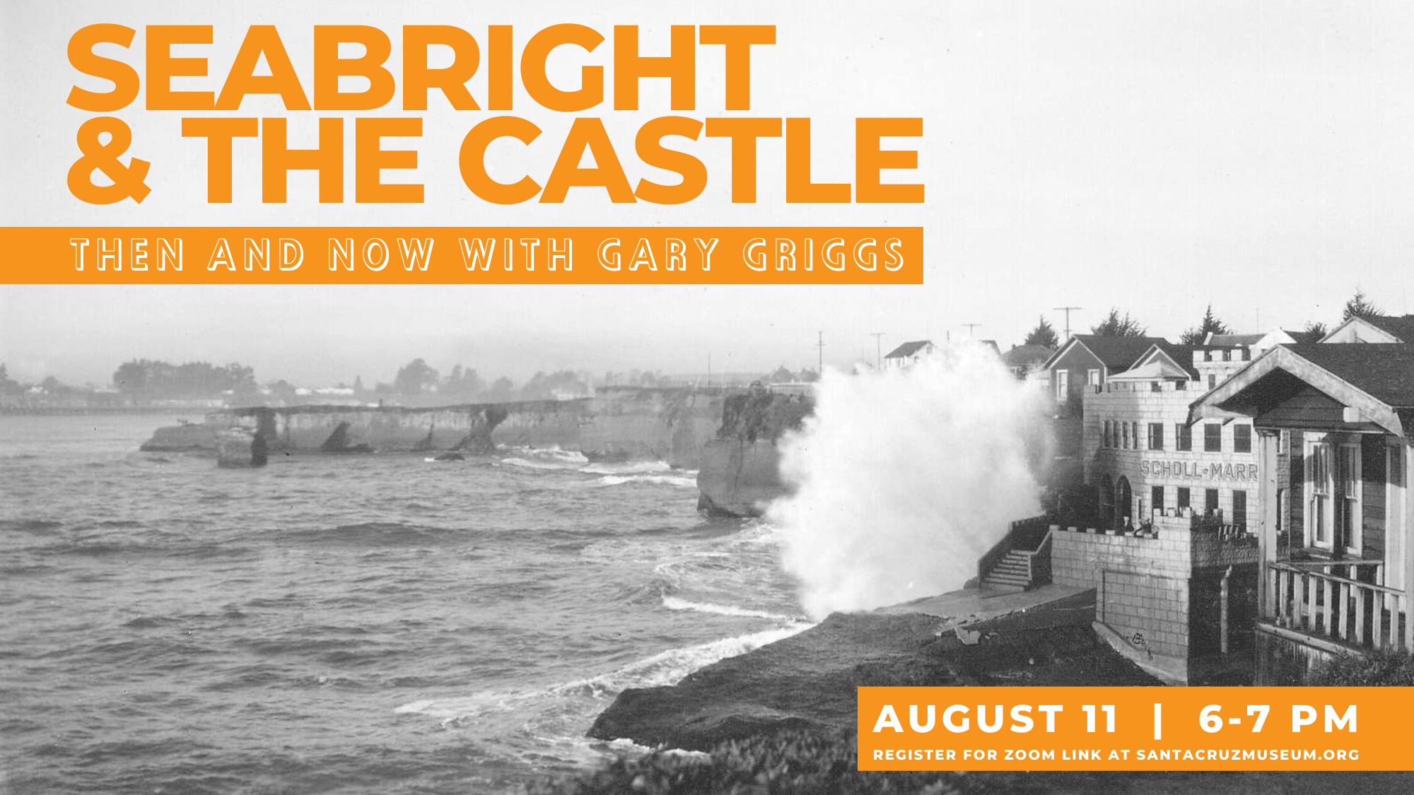
The climate, beautiful coastline, and majestic mountains that draw countless people to the Santa Cruz region every year were developed by the same forces that wreak havoc along the coast on a regular basis: floods, landslides, earthquakes, and storms.
Join Dr. Gary Griggs for a presentation about the historical and geologic context of the perils we endure to live in paradise, followed by a panel discussion featuring Tiffany Wise-West (Climate Action Program Manager for the City of Santa Cruz) and Nate Mantua (climate scientist for the National Oceanic and Atmospheric Administration (NOAA) Fisheries Office) where we will turn our attention to the future of this landscape, exploring the implications of climate change and community actions to address these challenges.
Thank you UC Santa Cruz and the Center for Coastal Climate Resilience for making the livestream and recording possible. The new center aims to advance campus research and to partner with state and federal agencies as well as private foundations to address coastal climate change, resilience, and sustainability.
About the Speaker
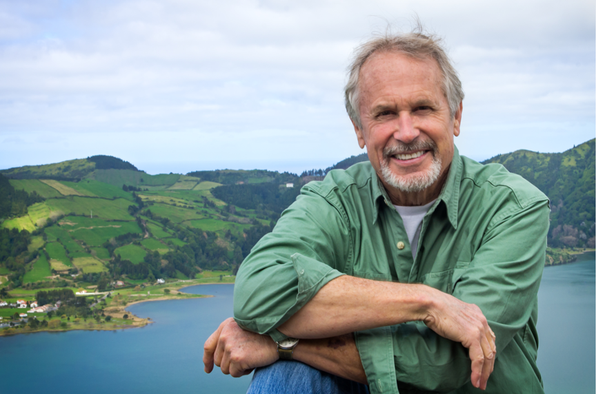
Gary Griggs is a Distinguished Professor of Earth & Planetary Sciences at the University of California Santa Cruz, where he has taught for 54 years. He received his B.A. in Geological Sciences in 1965 from the University of California Santa Barbara and a Ph.D. in Oceanography from Oregon State University in 1968. Gary served as the Director of the University’s Institute of Marine Sciences for 26 years, where he led the development of a Coastal Science Campus. His research, teaching, writing and lectures have been focused on the coast of California and include coastal processes, hazards, and the impacts of and responses to sea-level rise. Read more about Dr. Griggs.
Accessibility
The event will occur in the auditorium of London Nelson and is wheelchair accessible.
Santa Cruz’s scenic coastline has long enthralled residents and visitors alike, yet storms, relentless waves, and human impacts have and will continue to change our coastline. Join Dr. Gary Griggs for an examination of these processes through the lens of one of Santa Cruz’s most iconic beaches.
Castle (or Seabright) Beach went from being a very narrow seasonal beach to the one of the widest in the county following the construction of the Santa Cruz Small Craft Harbor. Seabright has long been a unique neighborhood with a character that has survived for well over a century. It was considered to be out in the country by Santa Cruz standards when it was first developed as a seaside resort in the 1880s. For years a rather makeshift footbridge over the San Lorenzo River was the main route into town. Each winter it had to be removed to keep the river from washing it away, and Seabright residents had to walk across the railroad bridge, considered dangerous at the time as there was no pedestrian walk as there is today.
Accessibility
A recording and follow-up resources will be shared with registrants after the program.
This program will be in English.
We will be using the webinar format, meaning that participants’ video and mic functions will be disabled.
Reasonable accommodation requests can be made by emailing events@santacruzmuseum.org.
About the Speaker
Gary Griggs is a Distinguished Professor of Earth & Planetary Sciences at the University of California Santa Cruz, where he has taught for 54 years. He received his B.A. in Geological Sciences in 1965 from the University of California Santa Barbara and a Ph.D. in Oceanography from Oregon State University in 1968. Gary served as the Director of the University’s Institute of Marine Sciences for 26 years, where he led the development of a Coastal Science Campus. His research, teaching, writing and lectures have been focused on the coast of California and include coastal processes, hazards, and the impacts of and responses to sea-level rise. In 1998 he was given the Outstanding Physical and Biological Sciences Faculty Award at U.C. Santa Cruz, and the Alumni Association honored him with a Distinguished Teaching Award in 2006. The California Coastal Commission and Sunset Magazine named him one of California’s Coastal Heroes in 2009, and in 2010 he was elected to the California Academy of Sciences. Gary chaired a committee in 2017 recommended by Governor Brown to update California’s sea-level rise projections. In 2016 he was appointed to the California Ocean Science Trust. Gary is also a member of the California Ocean Protection Council’s Science Advisory Team and served as chair of California’s 4th Climate Assessment Committee on Coasts and Ocean.
Gary has written 13 books including: Living with the Changing California Coast, Introduction to California’s Beaches and Coast, The California Coast from the Air, Coasts in Crisis – A Global Challenge, The Edge – The Pressured Past and Precarious Future of California’s Coast, Between Paradise and Peril – The Natural Disaster History of the Monterey Bay Region, and most recently The Ominous Ocean: Rogue Waves, Rip Currents and other Dangers along the Shoreline and at Sea.
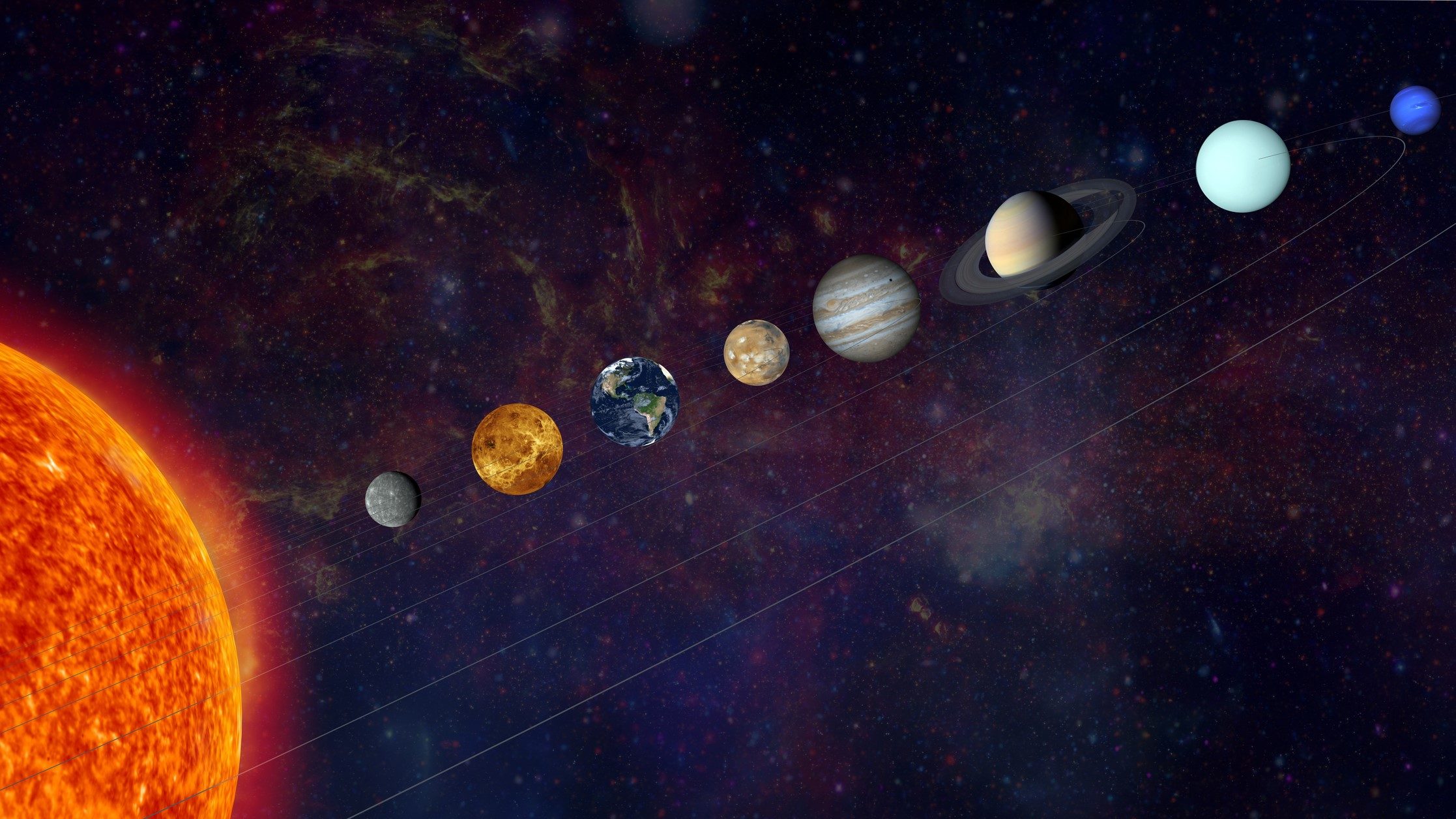
After two years and 35 programs, this month’s Rockin’ Pop-Up will be our final installment. Join the Geology Gents, Gavin and Graham, one last time for an exploration of our solar system. This third installment of our solar system trilogy will end at the beginning, examining how the sun, asteroids, and comets help us understand the origin of our solar system. Watch part one about the terrestrial planets and part two about the giants.
About the Series: Join the Geology Gents, Gavin Piccione and Graham Edwards, for monthly conversations about rocks live on Facebook. Each month we’ll explore a different geologic topic, from Santa Cruz formations to tips for being a more effective rockhound. Submit your questions ahead of time by emailing events@santacruzmuseum.org and feel free to include pictures of rocks you’d like identified! Note: you do not need to have a Facebook account to be able to watch the program live.
Join the Geology Gents, Gavin and Graham, for the second installment of a three-part trilogy exploring the planets of our solar system. March will examine the icy and gaseous planets known as “the giants” — Jupiter, Saturn, Uranus, and Neptune. Watch part one about the terrestrial planets.
About the Series: Join the Geology Gents, Gavin Piccione and Graham Edwards, for monthly conversations about rocks live on Facebook. Each month we’ll explore a different geologic topic, from Santa Cruz formations to tips for being a more effective rockhound. Submit your questions ahead of time by emailing events@santacruzmuseum.org and feel free to include pictures of rocks you’d like identified! Note: you do not need to have a Facebook account to be able to watch the program live.
What do rocks have to do with the ocean and the atmosphere? Well, quite a lot it turns out! Join us for our next Rockin’ Pop-Up where the Geology Gents will simplify the complexities of these important earth systems.
About the Series: Join the Geology Gents, Gavin Piccione and Graham Edwards, for monthly conversations about rocks live on Facebook. Each month we’ll explore a different geologic topic, from Santa Cruz formations to tips for being a more effective rockhound.
Submit your questions ahead of time by emailing events@santacruzmuseum.org and feel free to include pictures of rocks you’d like identified! Note: you do not need to have a Facebook account to be able to watch the program live.
One of the most exciting perks of having an appreciation for geology is the limitless possibility to find new geologic features, even on the most seemingly mundane trips outside. It may be an interesting pebble that catches your eye or a new outcrop that piques your interest, but one usually does not have to travel far to find thought-provoking rocks. However, within this vast collection of terrestrial curiosities, some features stand out as particularly exceptional or interesting.
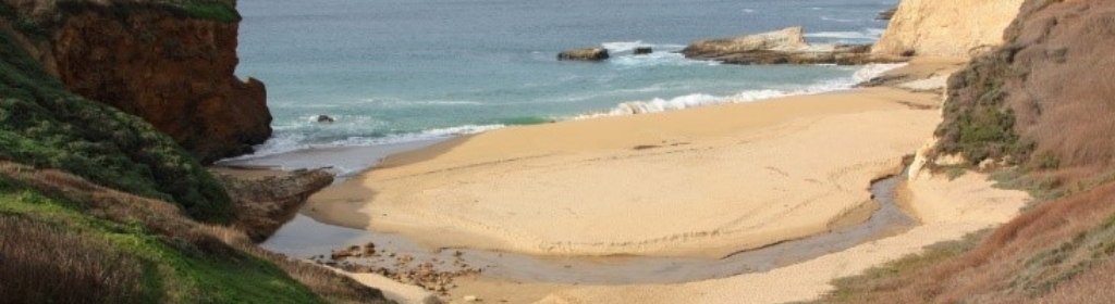
On a recent trip to Panther Beach, I experienced the thrill of discovering one of these remarkable geologic marvels hiding just up the coast. In this installation of Rock Record, I cover why the rocks at Panther Beach in Santa Cruz are a world-renowned sedimentary outcrop, and I investigate how this truly unique part of the cliff was deposited here.
The Rocks at Panther Beach
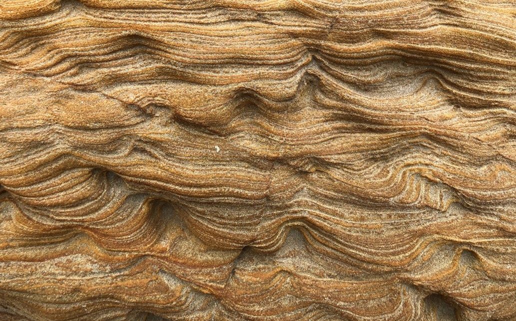
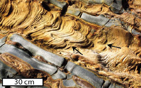
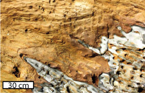
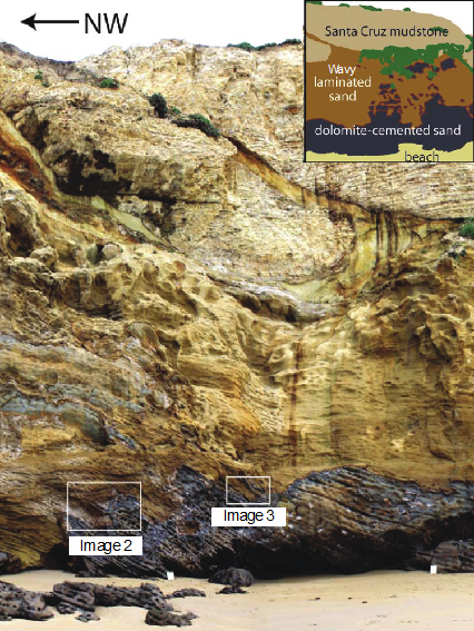
At first glance the rocks at Panther beach may look very familiar to folks who have spent time in Santa Cruz, with cliff walls of the main section of beach made up of the crumbly, beige sedimentary rock called Santa Cruz mudstone. However, if you head to the south-end of the beach, and pass under the archway, the rocks change drastically. Instead of the highly uniform mudstone, the rocks on this side are wavy, laminated sandstones (see image 1). Below these peculiar sandstones there are darker rocks, called dolomite-cemented sands, that have bands that tilt down and towards the southeast. If one breaks or scratches these dolomite-cemented sands, they may smell the faint odor of petroleum. The contact between these two rock types is high irregular, looking almost as if the dolomite-cemented sands were bubbled up into the wavy sandstones like liquid in a lava lamp (see images 2 and 3). Capping these two sandstones is the familiar Santa Cruz mudstone that makes up the rest of the cliff (see full outcrop in image 4).
Image 1: Wavy sandstone at Panther Beach
Image 2: Contact between the wavy sandstone, and the dolomite-cemented sandstone. Image from Sherry, et al. 2012
Image 3: Contact between the wavy sandstone, and the dolomite-cemented sandstone. Image from Sherry, et al. 2012
Image 4: Panther Beach outcrop. Image modified from Sherry et al. 2012
Formation of the Panther Beach Outcrop: The World’s Largest Sedimentary Injection Deposit
When geologists see large sections of rock that are unrelated to the surrounding rock, we often think of some surface process like motion along a fault, that may bring two different rock types in contact. However, at Panther Beach there is no evidence for a fault that could have brought the sandstones to the surface. So how did this ~100m section of sandstone become emplaced in a cliff that is otherwise made of Santa Cruz mudstone?
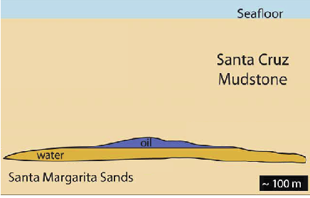
To understand the formation of the Panther beach outcrop we must start about 1 kilometer below the seafloor. Around 9 million years ago off the coast of ancient Santa Cruz, 1000 meters of mud (the Santa Cruz mudstone) was deposited at the bottom of the ocean above a thick sand deposit (the Santa Margarita sandstone). Later, after heat, and pressure turned most of these sediments into rock, the only sediments left were small pockets of Santa Margarita sands that had not been lithified (i.e., turned to rock). Portions of these sand pockets were rich in oil, which created two distinct reservoirs: oil-rich sands and oil-poor sands. These two sand types were spatially separated because of the density difference between oil and water (see image 5).
Image 5: Sediments prior to injection. Schematic modified from Sherry, et al. 2012.
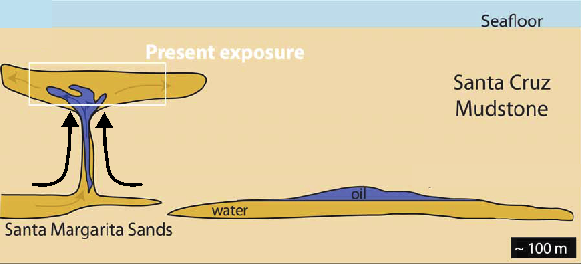
As more mud was deposited atop the Santa Margarita Sands, the pressure on the sand built. Then finally a geologic event, probably either an earthquake or a landslide, shook the sediments causing the slurry of both oil-rich and oil-poor sands to be injected, at a high velocity, into the overlying rock through fractures in the Santa Cruz mudstone. This type of formation is called a sediment injection deposit, where sediments from below are squeezed up into the overlying strata like a tube of toothpaste (see image 6). While the sands were injected, the oil-rich sand slurry would have traveled slower than the oil-poor sands, leaving the oil rich sands below the oil-poor sands. Injection deposits occur in other places on Earth, but the Panther Beach outcrop is the largest sedimentary injection deposit in the world!
Image 6: Sediments after injection. Schematic modified from Sherry, et al. 2012.
Getting to the Panther Beach Outcrop
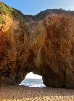
Image 7: View looking towards the south through the archway in the cliff
Panther Beach is located off Highway 1 about 5 miles north of Santa Cruz. The parking lot for beach access is unmarked but can be found on google maps. The walk to the beach is about 50 yards down a narrow, steep trail (see the image at the start of this post for the view from the top of the trail). Once on the beach, turn left and walk under the arch in the cliff (see image 7). Be careful, this passageway may not be accessible at high tide, use caution when walking through and do not try to pass when water is high! The sedimentary injection deposit makes up the sea cliff beyond the south side of the arch.
The GPS coordinates for Panther Beach are: 36.994, -122.169
Sherry, T. J., Rowe, C. D., Kirkpatrick, J. D. & Brodsky, E. E. Emplacement and dewatering of the world’s largest exposed sand injectite complex. Geochemistry, Geophys. Geosystems13, 1–17 (2012).
Santa Cruz is an area of geologic interest with a complex history of processes that shaped the coastline, bluffs, terraces, and mountains we see today! Wind, waves, earthquakes, fires, and other natural forces have changed and shaped the landscape for millions of years, though humans have only been able to document those changes in the recent past.
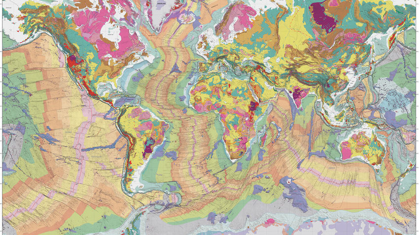
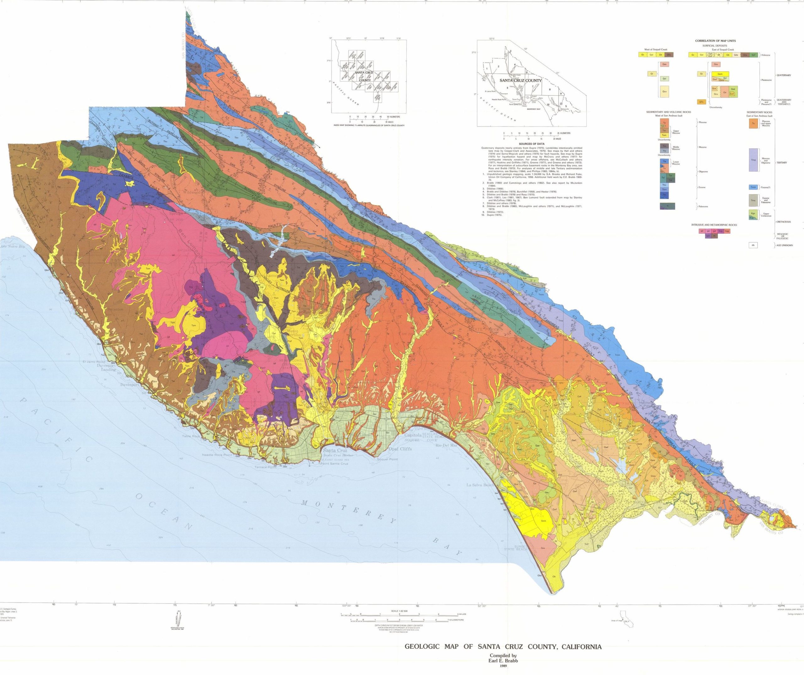
The above map shows the distribution of different rocks in Santa Cruz County. Each color represents a different kind of rock and, in turn, a particular age. Many of these rocks represent formations.
A geological formation is a basic rock unit that geologists use to group rock layers. Each formation must be distinct enough for geologists to tell it apart from surrounding layers and identify it on a map. A formation can consist of a variety of related or layered rocks, rather than a single rock type. There are over 14 geologic formations in Santa Cruz County. Most of these formations were created through movement of the crust because of tectonic uplift at the subduction zone off the California coast.
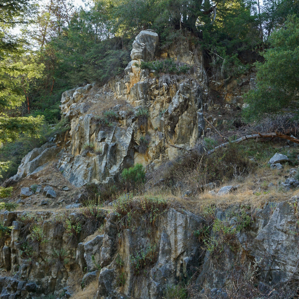
Most of the county is underlain by granitic rock. It formed about 100 million years ago from molten rock which cooled very slowly at a depth several miles below the earth’s surface. Since then, this area has been covered by the sea much of the time. Sand, mud and other sediment was deposited on the seafloor and was eventually compressed and hardened into sedimentary rock which was uplifted to form the Santa Cruz Mountains. Many of the sedimentary beds, which were originally horizontal, have been tilted, folded or partly eroded away. In some areas major faults have offset the rocks.
3 formations are known for fossils in this region: Purisima Formation (3-7 Ma) Santa Cruz Mudstone (7-9 Ma) Santa Margarita Formation (10-12 Ma)
The three basic types of rocks — igneous, metamorphic and sedimentary — occur in Santa Cruz County. All are composed of minerals. Some consist of primarily one mineral, as in the case of marble, while others are an aggregate of many different minerals, as in the case of granite and conglomerate.
Each rock type in the Santa Cruz area represents a different chapter in this region’s geologic past, and each has its own unique story to tell. The rocks of this area are mostly covered by soil and vegetation, so geologists must rely on scattered outcrops in creek beds, quarries, road cuts and sea cliffs in order to piece together the geologic history.
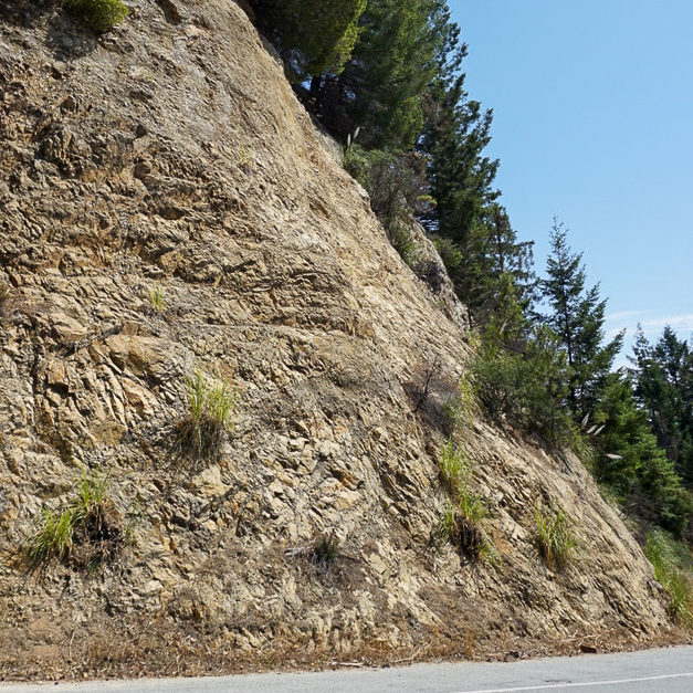
Granite, Empire Grade Road
Igneous rocks formed from molten rock called magma. Plutonic rocks, such as granite, gabbro and alaskite, cooled very slowly, solidifying deep below the earth’s surface. This provided time for larger crystals of quartz, feldspar, mica and other minerals to form, giving the rocks a coarse texture. Volcanic rocks, such as basalt, cooled quickly at the earth’s surface and are very fine grained.
Marble, UCSC Quarry
Themetamorphic rocksof this area are a geological enigma. They predate the granite rocks and were originally sedimentary rocks such as limestone, shale and sandstone. These were respectively metamorphosed into marble, schist and quartzite by the intrusion of magma about 100 million years ago. How much earlier these rocks were laid down as sediment, however, remains a mystery.
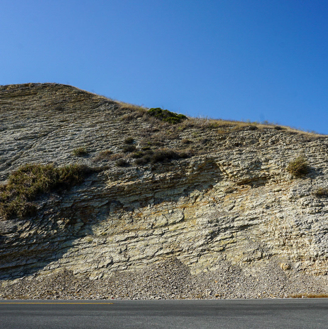
Mudstone, HWY 1 North of Santa Cruz
Sedimentary rocks in the Santa Cruz area originated for the most part from sediment such as mud, sand and gravel that was deposited on the sea floor. Over millions of years chemical alteration and pressure from burial hardened the sediment into rock. These rocks overlie the igneous and metamorphic rocks of this region and are of a younger age.
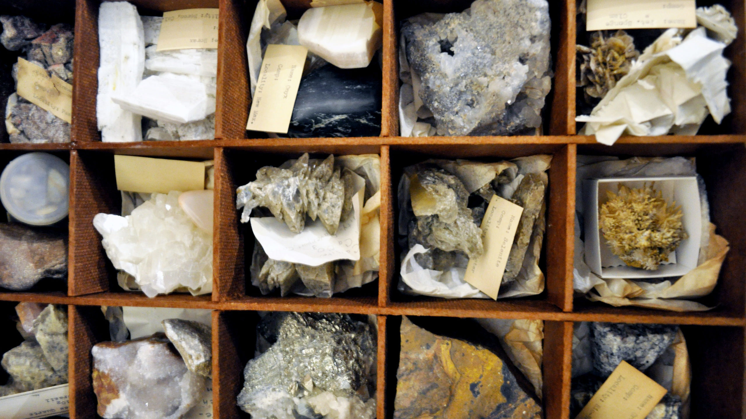
Minerals
Minerals are the naturally occurring crystalline substances that make up the rocks around us. Minerals such as quartz, feldspar, and calcite are the most common constituents of rocks in this area. Dozens of other mineral species occur here, but in small amounts. Large, well-formed crystals- the kind most sought after by collectors- are scarce.
Several minerals in this region have proven to be of great economic importance. Cinnabar (the chief ore of mercury) has been mined extensively at the New Almaden on the east slope of the Santa Cruz Mountains. Calcite (in the form of marble) has long been quarried near Santa Cruz for the manufacturing of lime and cement.
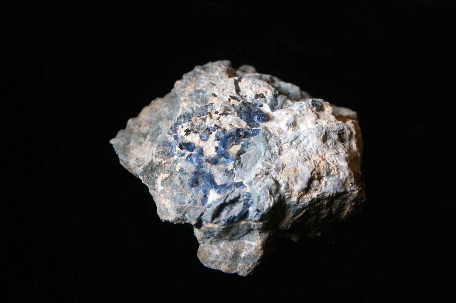
Benitoite is the California state mineral. This unusual blue crystal was first discovered in 1907 in San Benito County. While benitoite is found in a few places around the world, San Benito County is the only place in the world where gem quality benitoite crystals are found.
Garden: Take a stroll around the Museum’s Garden Learning Center and see if you can spot fossils and other large rock samples.
Activities for kids: Multiple dig boxes features Santa Margarita Formation fossils of sand dollars and casts of a fossil sea cow.
Bring rocks home
Rent a kit to explore local rocks at home. Kit rentals are $10 per week and can be requested here (you do not need to be a teacher to request a rental).
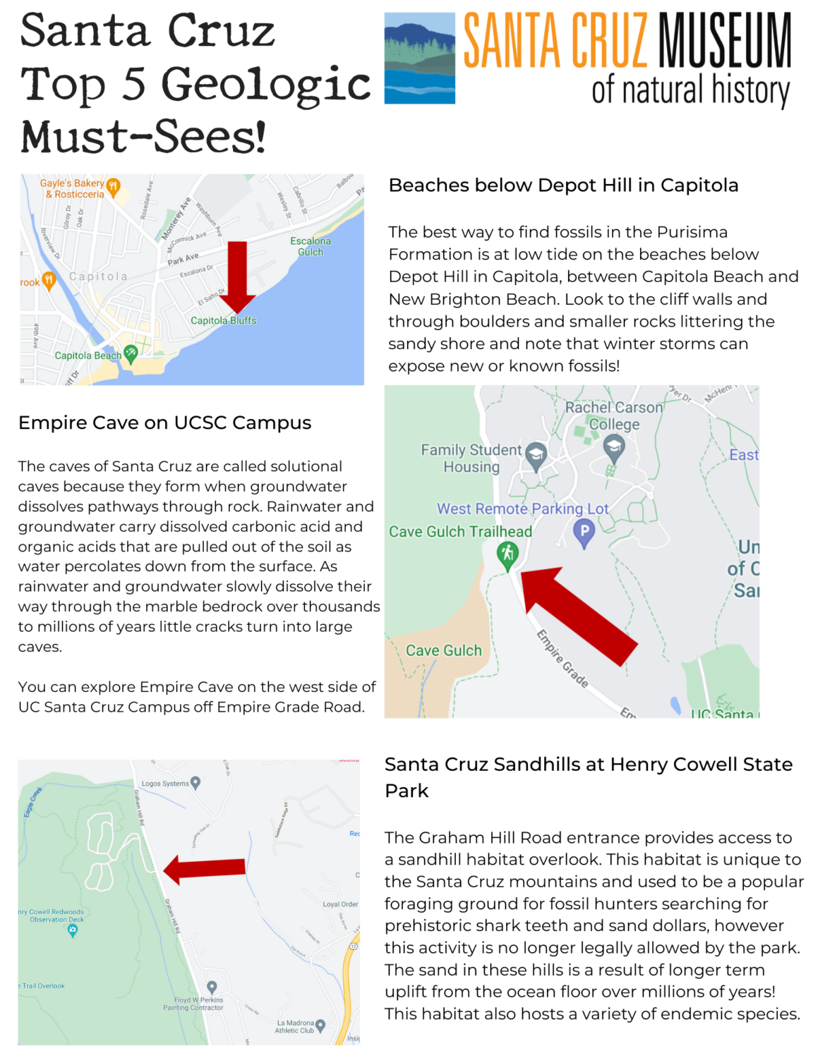
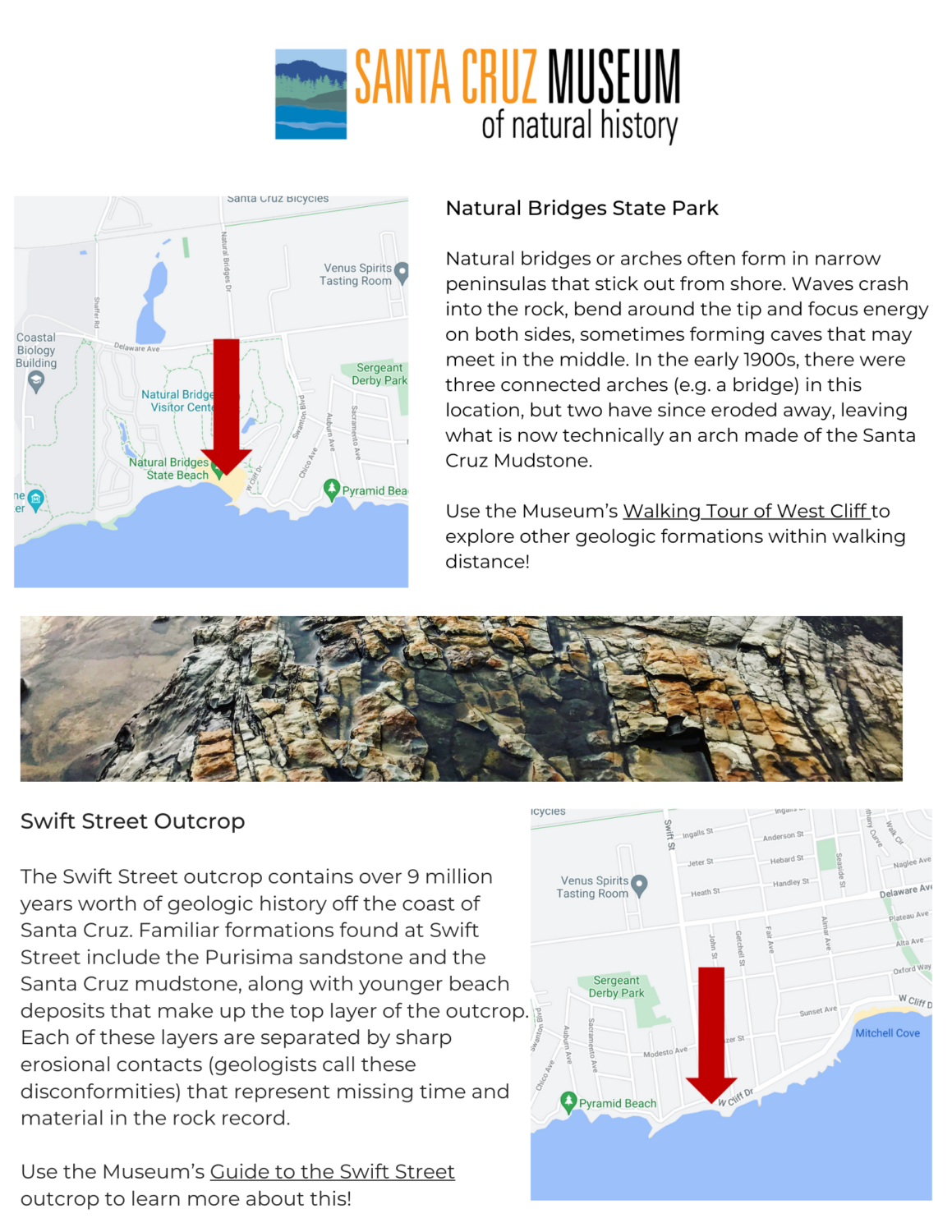
Santa Cruz is an area of geologic interest with a complex history of processes that shaped the coastline, bluffs, terraces, and mountains we see today! Use this map as you walk, bike or ride your way across the county and explore some of the geologic must-sees our area has to offer. Visit our online Guide to the Rocks of Santa Cruz County to dig even deeper into the geology of the region.