fbpx

Rock Record: Panther Beach, an Extraordinary Geologic Feature in Santa Cruz

Written by Gavin Piccione

One of the most exciting perks of having an appreciation for geology is the limitless possibility to find new geologic features, even on the most seemingly mundane trips outside. It may be an interesting pebble that catches your eye or a new outcrop that piques your interest, but one usually does not have to travel far to find thought-provoking rocks. However, within this vast collection of terrestrial curiosities, some features stand out as particularly exceptional or interesting.

On a recent trip to Panther Beach, I experienced the thrill of discovering one of these remarkable geologic marvels hiding just up the coast. In this installation of Rock Record, I cover why the rocks at Panther Beach in Santa Cruz are a world-renowned sedimentary outcrop, and I investigate how this truly unique part of the cliff was deposited here.

The Rocks at Panther Beach

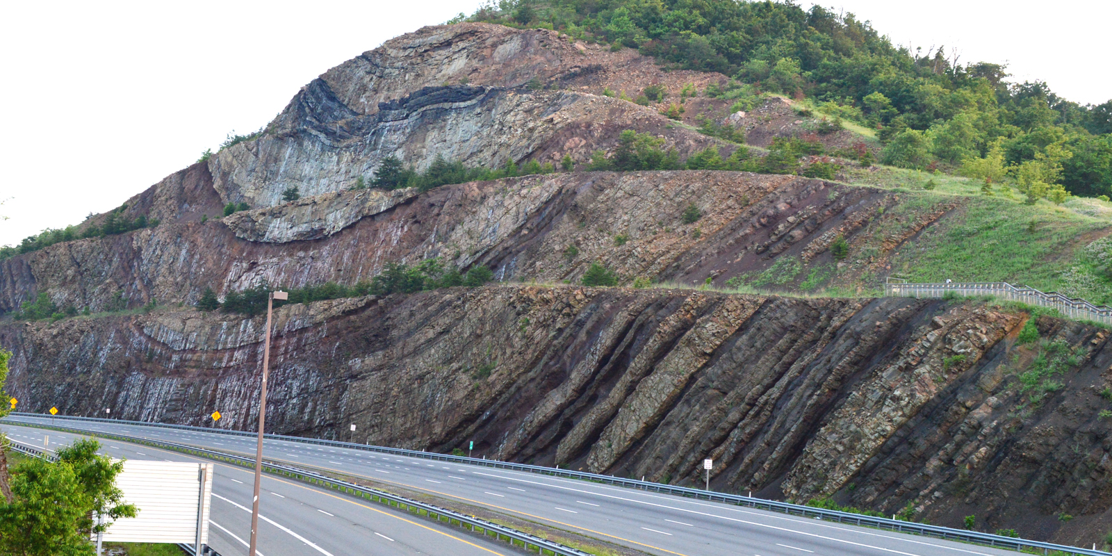
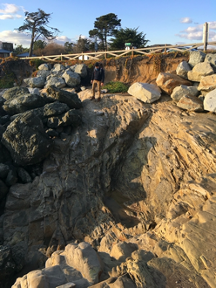
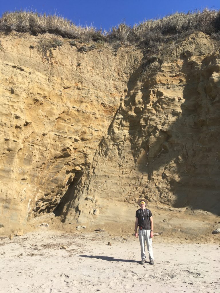
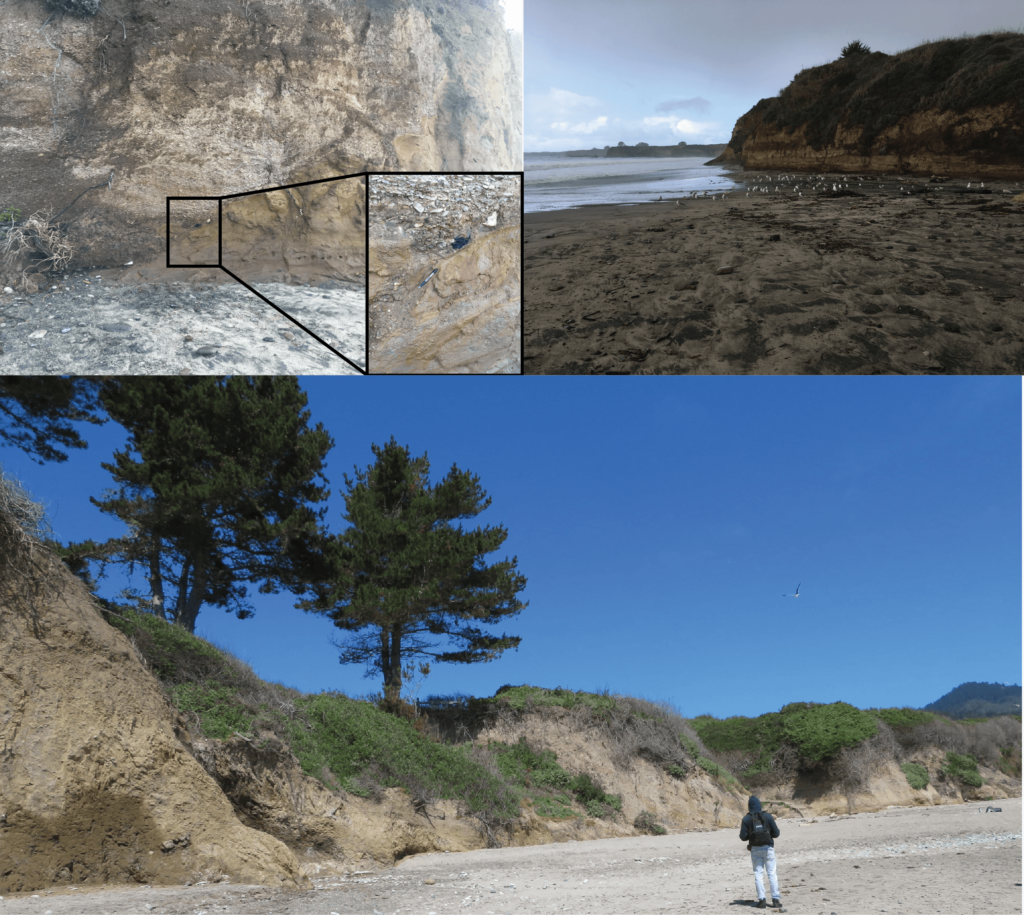
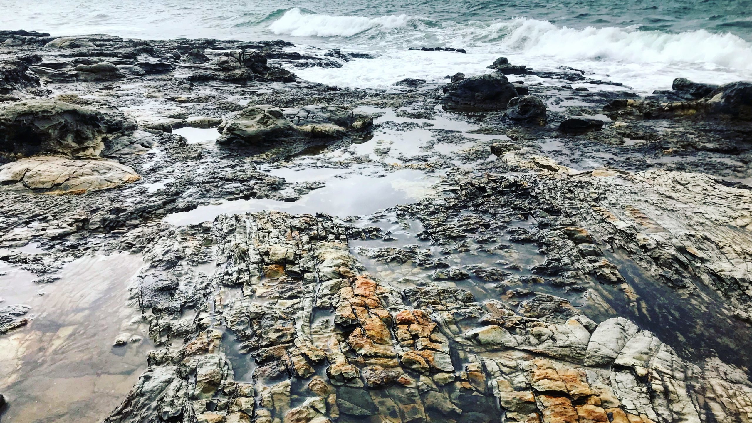
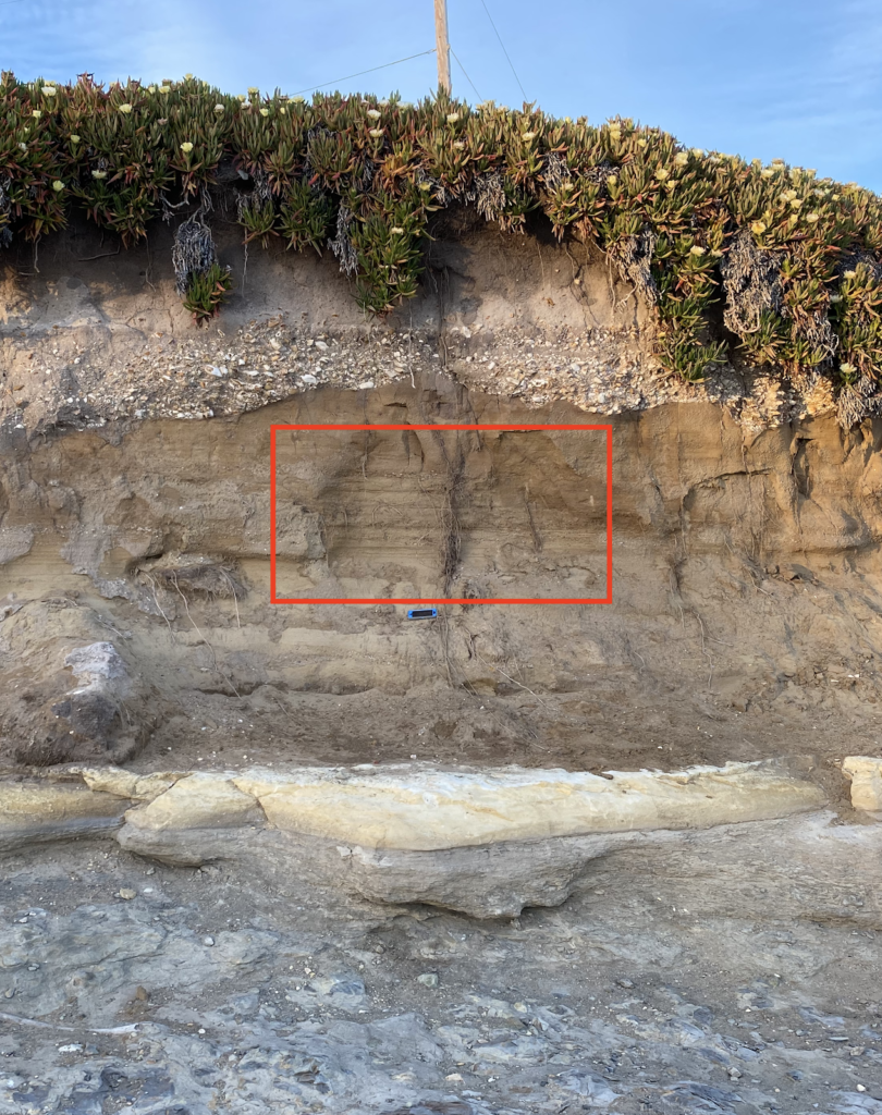
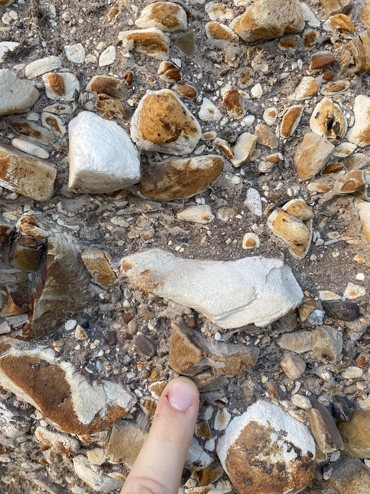
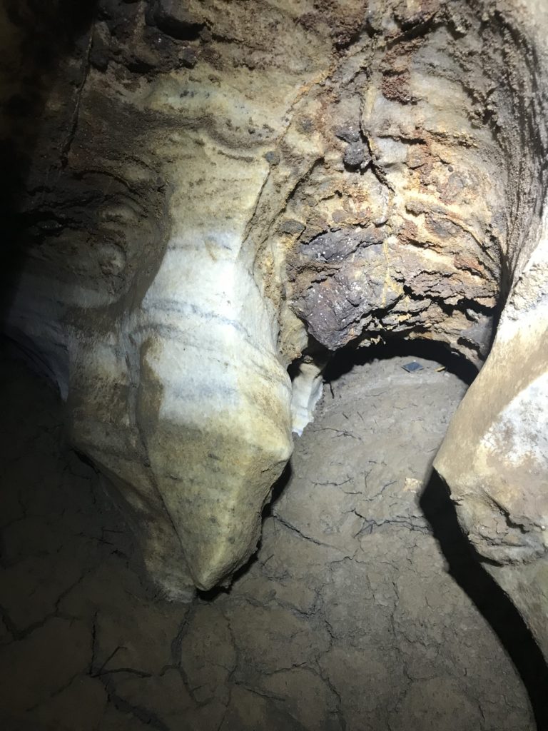
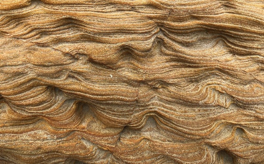
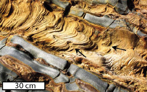
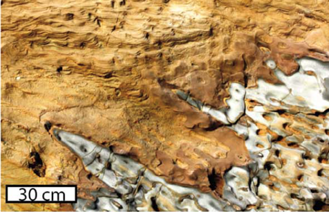
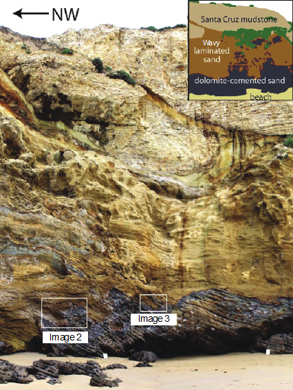
At first glance the rocks at Panther beach may look very familiar to folks who have spent time in Santa Cruz, with cliff walls of the main section of beach made up of the crumbly, beige sedimentary rock called Santa Cruz mudstone. However, if you head to the south-end of the beach, and pass under the archway, the rocks change drastically. Instead of the highly uniform mudstone, the rocks on this side are wavy, laminated sandstones (see image 1). Below these peculiar sandstones there are darker rocks, called dolomite-cemented sands, that have bands that tilt down and towards the southeast. If one breaks or scratches these dolomite-cemented sands, they may smell the faint odor of petroleum. The contact between these two rock types is high irregular, looking almost as if the dolomite-cemented sands were bubbled up into the wavy sandstones like liquid in a lava lamp (see images 2 and 3). Capping these two sandstones is the familiar Santa Cruz mudstone that makes up the rest of the cliff (see full outcrop in image 4).

Image 1: Wavy sandstone at Panther Beach
Image 2: Contact between the wavy sandstone, and the dolomite-cemented sandstone. Image from Sherry, et al. 2012
Image 3: Contact between the wavy sandstone, and the dolomite-cemented sandstone. Image from Sherry, et al. 2012
Image 4: Panther Beach outcrop. Image modified from Sherry et al. 2012

Formation of the Panther Beach Outcrop: The World’s Largest Sedimentary Injection Deposit

When geologists see large sections of rock that are unrelated to the surrounding rock, we often think of some surface process like motion along a fault, that may bring two different rock types in contact. However, at Panther Beach there is no evidence for a fault that could have brought the sandstones to the surface. So how did this ~100m section of sandstone become emplaced in a cliff that is otherwise made of Santa Cruz mudstone?

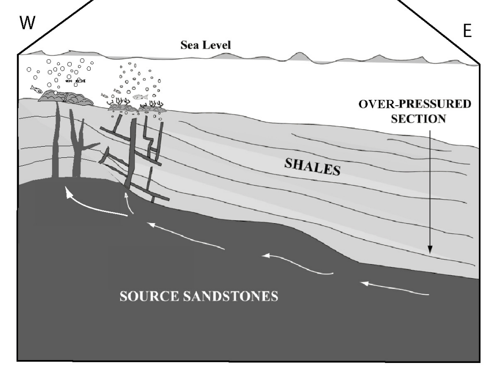
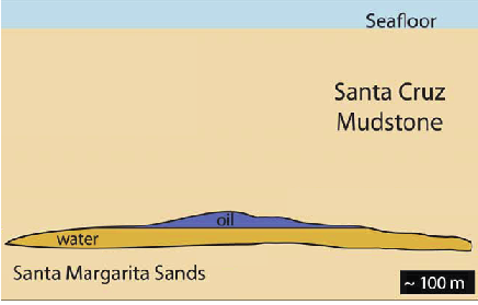
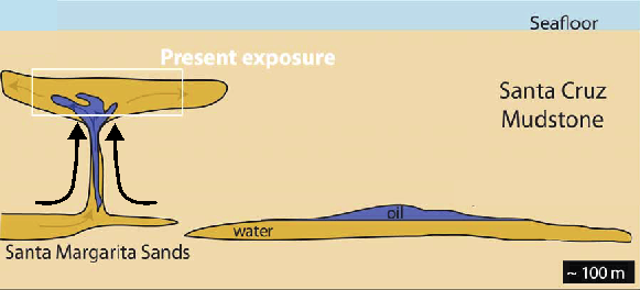
To understand the formation of the Panther beach outcrop we must start about 1 kilometer below the seafloor. Around 9 million years ago off the coast of ancient Santa Cruz, 1000 meters of mud (the Santa Cruz mudstone) was deposited at the bottom of the ocean above a thick sand deposit (the Santa Margarita sandstone). Later, after heat, and pressure turned most of these sediments into rock, the only sediments left were small pockets of Santa Margarita sands that had not been lithified (i.e., turned to rock). Portions of these sand pockets were rich in oil, which created two distinct reservoirs: oil-rich sands and oil-poor sands. These two sand types were spatially separated because of the density difference between oil and water (see image 5).

Image 5: Sediments prior to injection. Schematic modified from Sherry, et al. 2012.

As more mud was deposited atop the Santa Margarita Sands, the pressure on the sand built. Then finally a geologic event, probably either an earthquake or a landslide, shook the sediments causing the slurry of both oil-rich and oil-poor sands to be injected, at a high velocity, into the overlying rock through fractures in the Santa Cruz mudstone. This type of formation is called a sediment injection deposit, where sediments from below are squeezed up into the overlying strata like a tube of toothpaste (see image 6). While the sands were injected, the oil-rich sand slurry would have traveled slower than the oil-poor sands, leaving the oil rich sands below the oil-poor sands. Injection deposits occur in other places on Earth, but the Panther Beach outcrop is the largest sedimentary injection deposit in the world!

Image 6: Sediments after injection. Schematic modified from Sherry, et al. 2012.

Getting to the Panther Beach Outcrop

Image 7: View looking towards the south through the archway in the cliff

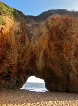
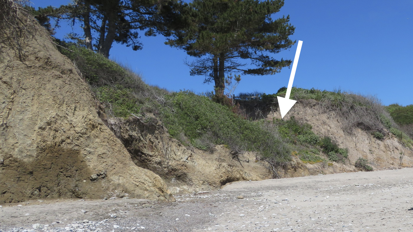
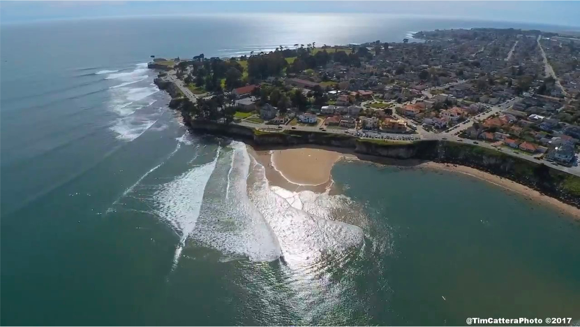
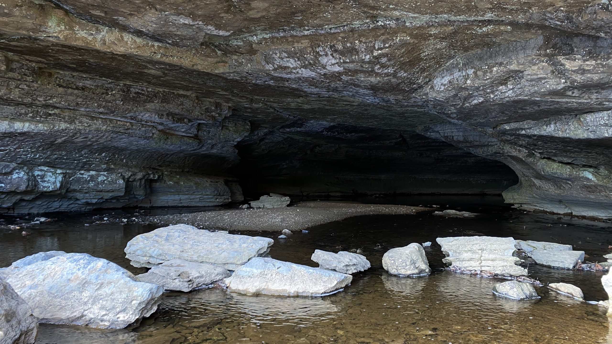
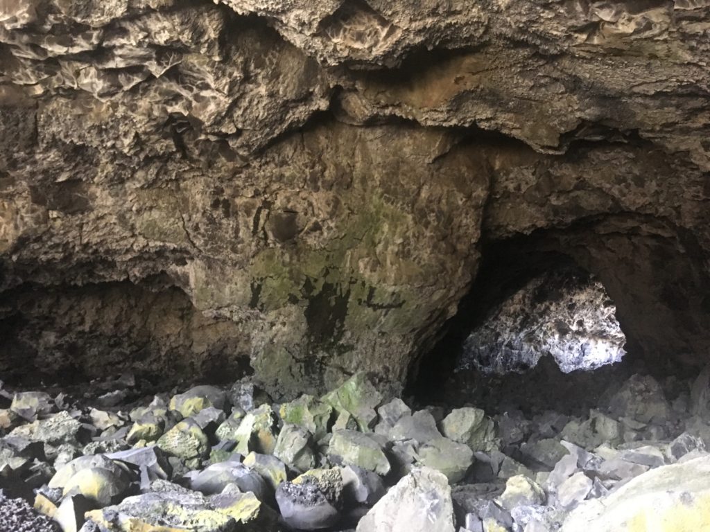
Panther Beach is located off Highway 1 about 5 miles north of Santa Cruz. The parking lot for beach access is unmarked but can be found on google maps. The walk to the beach is about 50 yards down a narrow, steep trail (see the image at the start of this post for the view from the top of the trail). Once on the beach, turn left and walk under the arch in the cliff (see image 7). Be careful, this passageway may not be accessible at high tide, use caution when walking through and do not try to pass when water is high! The sedimentary injection deposit makes up the sea cliff beyond the south side of the arch.

The GPS coordinates for Panther Beach are: 36.994, -122.169


Much of the information for this edition of Rock Record was first published in the journal article: Emplacement and dewatering of the world’s largest exposed sand injectite complex, by Timothy Sherry and others.

Reference cited:

Sherry, T. J., Rowe, C. D., Kirkpatrick, J. D. & Brodsky, E. E. Emplacement and dewatering of the world’s largest exposed sand injectite complex. Geochemistry, Geophys. Geosystems 13, 1–17 (2012).

Rock Record: A Closer Look at a Few of the Great Geologic Landmarks of the United States

Written by Gavin Piccione

The rocks on the surface of the Earth are shaped and transformed by the boundless forces of nature, creating a vast and ever-changing arrangement of formations for humans to observe and ponder. Even though the terrain of the U.S. comprises less than 2% of the Earth’s surface, the wide variety of environments found here gives rise to a diverse set of geologic wonders. In this installment of Rock Record, we will take a closer look at the mechanisms that formed some of the most distinctive and interesting of these geologic landmarks.

Delicate Arch in Arches National Park, Utah. Photo credit: Wikipedia user Palacemusic.

The Arches of Arches National Park

Unlike the natural bridges here in Santa Cruz, the arches of Arches National Park are not the result of localized erosion from waves. So how did these enigmatic features form?

The famous arches are a marvelous geologic coincidence, stemming from three key processes that unfolded over the past 300 million years. The first factor leading to the arches was the deposition of massive salt layers by an inland sea 300 million years ago. In the ensuing time, denser, stronger sandstones were deposited on top of these salt layers and the weight of the overlying rocks, combined with tectonic forces in the region (the second arch forming factor), caused the salt layers to bulge and push to the surface. The combined effects of the tectonic forces and the underlying salt layers created a massive anticline, or convex rock fold, in the overlying sandstones (see the schematic below).

Schematic of the geologic processes leading to arch formation.

As this bulge in the Earth was eroded away, folded sandstone layers were then exposed at high angles at the surface. Because the sandstone layers were less erodible than some of the surrounding rocks they were left behind, jutting out of the earth surface in formations known as “fins” (see photos below). It was from these fins that the arches were eventually formed.

Schematic of Arch formation from Sandstone “fins”. Image courtesy of the National Park service.

The final arch forming factor was localized fracturing from faulting within the fins. Tectonic processes caused faults along small, weak shale layers within the sandstone columns, leading to highly fractured zones. Over time, wind and rain plucked these fractured zones from the fins, leaving behind the arches we see today.

Photo of Mono Lake tufa towers. Photo credit: oakdaleleader.com.

The Mono Lake Tufa Towers

Above the quiet waters of Mono Lake, the tufa towers stand like a peculiar shrine to the geologic processes operating in this area east of the Sierra Nevada. The conditions that created the otherworldly tufa were an intersection between the realms of chemistry, geology and hydrology, forming tufa towers throughout the ~760,000-year life of Mono Lake.

To understand the formation of the tufa, it is easiest to start by analyzing the setting of Mono Lake: Mono Lake lies in a basin that allows water to flow in, but not out. Meaning that all of the dissolved rock particles that flow into the lake stay there, causing the lake waters to become very salty and to have a very high pH (e.g. Acids like vinegar and lemon juice have low pH, while bases like baking soda and ammonia have high pH.) These lake conditions are conducive to high levels of the molecule carbonate (CO3), one of building blocks for “carbonate” minerals.

In addition to the surface lake waters, there are abundant groundwaters that flow into the basin from surrounding areas, which interact with the rocks as they flow towards the lake and become high in the element calcium. As these ground waters flow into the lake through underwater springs, the groundwater and lake water mix, causing the carbonate molecules and calcium from the two respective waters to bond, and form the tufa towers from the mineral calcite. This means that every tufa tower is a fossilized spring! Unfortunately, there is also a human induced component of the tufa towers we see today: when the city of Los Angeles diverted freshwater that once flowed into Mono Lake it caused lake levels to fall dramatically, leading to exposure of previously underwater tufa (see schematic of tufa formation below.)

Schematic of tufa formation from mixing of lake and ground waters (left and middle) and exposure through falling lake levels (right).
Aerial photo of Great Sand Dune National Park. Photo credit: The Denver Post.

The Dunes at Great Sand Dunes National Park

Sand dunes probably seem mundane for folks living in Santa Cruz who’ve likely seen the coastal sand dunes on the drive from Santa Cruz to Monterey. However, it may come as a surprise that the tallest sand dunes in North America are far from the ocean and are not associated with grand deserts like the Mojave either, but instead are found right in the middle of Colorado!

The dunes at Great Sand Dune National Park lie along the eastern edge of the San Luis basin between the San Juan Mountains to the west and the Sangre de Cristo Mountains to the east. This basin used to hold the massive Lake Alamosa, which drained around 440,000 years ago. Following the lake drainage, sediments from the lake bottom and the surrounding mountains began to build up in on the basin floor (see maps below).

Idealized maps of the San Luis Basin before (left) and after (right) Lake Alamosa drained. Map credit: National Park Service.

The location of this basin in the greater Rocky Mountains funnels wind from the southwest, causing the sand dunes to grow in a natural pocket in the Sangre de Cristo Mountains. During storms events, opposing winds are driven from the east, causing the dunes to grow to their great heights (see image below).

Aerial photo of the great sand dunes in their natural pocket in the Sangre de Cristo Mountains.

Learn more about our nation’s geologic landmark, including some closer to home, during May’s Rockin’ Pop-Up.


Rock Record is a monthly blog featuring musings on the mineral world from Gavin Piccione and Graham Edwards, PhD candidates in geochronology with the Department of Earth and Planetary Sciences at UC Santa Cruz. They also host our monthly Rockin’ Pop-Ups as “The Geology Gents”.

New Perspectives on the Past Through Freshly Exposed Rocks

In this edition of Rock Record, the Geology Gents unearth a few key examples of how newly exposed outcrops have led to important geological insights, as well as some geologic exploration into freshly exposed rock and sediments exposed by the CZU Lightning Complex Fires. 

By Graham Edwards and Gavin Piccione (aka the Geology Gents)

To reconstruct Earth history, geologists rely on the rock record: the accumulated rocks that, through their accumulation and formation, are relics of ancient geologic processes spanning geologic history. Such rocks provide a spyglass with which to peer into geologic history. But our view through this spyglass is limited to rocks that are both exposed at the Earth’s surface and have survived the effects of erosion.

As geologists, we often rely on Earth processes to expose new rocks and provide us fresh glimpses into Earth’s history. Since exposing fresh rock requires a lot of energy, natural disasters or extreme natural events can expose clues to this history through fresh rock surfaces. Human activities, such as construction or mining, can also expose new geological wonders.

In this edition of Rock Record, we’ll go through a few key examples of how newly exposed outcrops have led to important geological insights, as well as some geologic exploration into some freshly exposed rock and sediments exposed by the CZU Complex Fire.

Roadcuts

Roadcut in Maryland exposing large folds. Image credit: Joel Duff, Naturalis Historia

The construction of roads often requires the removal of large sections of rock, leaving sheer rock faces on the sides of the road. Some of the most famous rock outcrops are ones exposed in roadcuts and these unique locations are a frequent destination for college geology classes.

As undergraduates, the Gents (i.e. Gavin and Graham) explored roadcuts in the Northeastern US, and learned about tectonic motion through the faults and folds exposed in roadcuts (like the one in the image to the right), about metamorphic rocks via roadcuts in Maine, and about large deep-sea sediment avalanches (called turbidites) from roadcuts in upstate New York. Rocks exposed on the sides of roads can also be significant for geologist’s understanding of the sequence of events in an area.

For instance, a roadcut in Owens valley (see image below), settled a longstanding debate amongst geologists about whether the Bishop Tuff was deposited before or after the first glaciations in the area. The exposed rock showed the Bishop Tuff sitting on top of the Sherwin Till glacial deposit, meaning that the tuff must have been deposited after the till.

Roadcut in Owens valley showing the Bishop Tuff overlying the Sherwin Till. Original image taken by James St. John

Fire

Forest fires are, in many cases, an important natural event for the health of a forest because they clear the forest floor of brush and dead vegetation. Through this process, fires also expose large portions of rock that would otherwise not be visible. For this addition of Rock Record, the Gents explored some areas of the Santa Cruz mountains that have been burned in the CZU Lightning Complex fires last August.

Taking Empire Grade North, areas of Cretaceous (145-66 million years before present) igneous and metamorphic rocks that were previously covered by vegetation are exposed in the burn zone of the recent fires.

Weather

Sometimes extreme weather events can expose new outcrops or geologic features. For instance, the Frijoles Fault of a previous Rock Record post, The Faults that Shape Santa Cruz, was hidden behind trees and shrubs until a powerful storm event in the 1970s drove enough coastal erosion to expose the fault in the sea cliffs. Even more recently, heavy rains can cause landslides on the steep topography of the Santa Cruz Mountains and Santa Lucia Mountains of Big Sur. Each of these landslides exposes new surfaces that allow geologists and geomorphologists to study what causes landslides and the ways that massive amounts of Earth can be rapidly moved down hillslopes.

The exposed Frijoles fault contact, which was long hidden behind trees and shrubs before it was revealed by a storm in the 1970s.

Meteorites 

Some rocks are truly out of this world! Rocks that formed beyond Earth and arrive on Earth are called meteorites. Most meteorites come from the asteroid belt, a ring of rocky debris that dwells between the orbits of Mars and Jupiter, while some meteorites come from Mars and the Moon. As any Earth dweller knows, meteorites are incredibly rare, but they are important samples of other celestial bodies and leftovers from planet formation that we can study in close detail here on Earth. So, a meteorite fall is an incredibly exciting event for planetary scientists and geologists, alike!

One of the most important meteorites ever to land on Earth was the Allende meteorite, which landed in 1969 near the town of Pueblito de Allende in the state of Chihuahua in northern Mexico. The stone broke into pieces before it landed on Earth, but the collected chunks of this meteorite total >4,000 pounds with more pieces still found today! Because there was so much meteorite to go around, many scientists have studied it, and since the Allende meteorite is made of some of the most ancient material in our solar system it has provided an invaluable window into the earliest moments of our solar system just after the Sun formed!

What mysteries do you suppose are hiding all around you, covered by trees, houses, or soil?


Rock Record is a monthly blog featuring musings on the mineral world from Gavin Piccione and Graham Edwards.

Graham Edwards and Gavin Piccione are PhD candidates in geochronology with the Department of Earth and Planetary Sciences at UC Santa Cruz. They also host our monthly Rockin’ Pop-Ups as “The Geology Gents”.

Rock Record: The Faults that Shape Santa Cruz

In this installation of Rock Record, we explore how faults shape Santa Cruz. First, a little about faults.

By Graham Edwards and Gavin Piccione (aka the Geology Gents)

Image: San Andreas Fault. Credit: Kate Borton, David Howell, and Joe Vigil.

Faults are flat fracture surfaces within rock where portions of the rock move past each other. These features are some of the most prominent ways geologic processes shape the surface of the Earth. Motion along faults is responsible for the creation of most of the Earth’s mountains and valleys; faults significantly impact how and where rocks are eroded; and motion across faults causes earthquakes. In California, the most iconic fault is the continent-scale San Andreas Fault, but faults in this area occur at a wide range of sizes and often create familiar landscape features.

The Creation of the Santa Cruz Mountains

Faults of the Bay Area. Credit: UC Berkeley Seismology Lab.

Plate tectonics drive fault motion, creating large fracture surfaces in the Earth’s crust as the plates move apart, alongside, or crash into each other. Along the San Andreas, this plate motion is primarily horizontal (side-to-side), as the Pacific plate moves North and the North American plate moves South.

Major faults like the San Andreas are not actually one single fault, and instead make up fault zones, or networks of parallel faults that take up portions of the overall motion. Regional scale plate motion, like that responsible for the San Andreas, is often taken up by branching fault networks, instead of by one single fault zone. In the San Francisco Bay Area, the North-South motion of the Pacific and North American plate is taken up by four major faults: San Andreas, San Gregorio, Hayward, and Calaveras (right).

A careful look at the trace of the main San Andreas Fault reveals that this fault is not perfectly straight, but rather curves and wiggles a little bit. This complicates the motion of the fault. It is easy to slide two flat blocks past one another, but if you add bumps to these blocks, they are much harder to move. This is because when these bumps run into each other, they catch on one another. When these bumps are small (like sandpaper) it makes the fault hard to move. When these bumps are large, like the bend of the San Andreas Fault just north of Santa Cruz, the landscape in that bend can get squeezed together or pulled apart. Given the left-to-right motion of the San Andreas, the bend North of Santa Cruz squeezes the landscape together, thickening the crust and pushing the Earth upward to form the Santa Cruz Mountains.

The Faults in our Backyard

The Ben Lomond fault is the largest fault running through Santa Cruz, starting offshore in the Monterey Bay and weaving its way up into the Santa Cruz Mountains. Geologists know this fault was last active over 85,000 years ago, since it cuts through the older Purisima Sandstone and Santa Margarita Sandstone but does not disrupt the younger marine terrace deposits. The Ben Lomond fault is responsible for the path of the San Lorenzo river, which took advantage of rock that was fractured and weakened by motion along the fault.

Geologists from UCSC mapped the fault through Santa Cruz in the 1980’s, and for this installation of Rock Record we tracked the areas where this fault is visible from West Cliff drive up through Felton.

West Cliff Outcrop

The Ben Lomond fault first outcrops (geologist jargon for becomes visible in rock) on West Cliff Dr. in Santa Cruz, at the end of Woodrow Avenue, just west of Mitchell’s Cove Beach. This outcrop is a subtle, tight notch in the cliff. When compared to other rocks along the sea cliff, the rocks in the Woodrow Ave. outcrop are much more fractured, which is a result of more intense rock deformation caused by motion along the fault. Note, the large, dark boulders along this section of the cliff were placed there to prevent erosion.


Escalona Dr. Outcrop

Because the Ben Lomond fault is younger than the marine rocks that make up most of Santa Cruz, evidence of its existence does not appear in many areas South of Felton. One exception is along Escalona Dr., where the fault creates a small notch in the north side of street on private property.


Fault Scarp on UCSC campus

While an outcrop of the Ben Lomond fault is not visible between Escalona Dr. and Felton, evidence of motion along the fault can be seen along Coolidge Dr. on the UCSC campus. On the west side of the road, there is a steep drop down into Pogonip park. This ledge, termed a fault scarp, was made by motion along the Ben Lomond fault, where the east side of the fault was push upwards and the west side downwards. 


Outcrop Along the San Lorenzo in Henry Cowell State Park

North of UCSC, the Ben Lomond fault runs parallel (and sometimes through) the San Lorenzo River. In Henry Cowell State park, just north of the “Garden of Eden” swimming hole, the Ben Lomond fault can be seen along the west bank of the river. While subtle, this outcrop has some of the tell-tale signs of fault activity. Similar to the West cliff outcrop, there is pronounced fracturing of the rock in this area. Additionally, topography on the west side of the river reaches a low-point, which geologists term a saddle, where the rocks are more eroded.

A Detour North: Año Nuevo Faults

While the faults around Santa Cruz can be subtle or hard to get to, you don’t need to travel far to see faults and evidence of their activity. Año Nuevo State Park lies on the land where the trace of the San Gregorio Fault strikes dry land again (south of here it follows the coast just offshore). The San Gregorio Fault continues on its right-ward progress, dragging the westward/seaward portions of Año Nuevo to the northwest. Looking down at Año Nuevo State Park from the air, you can see the work of the San Gregorio Fault plainly. Año Nuevo Creek, which drains out of the steep mountains here, passes right by the visitor center and creates a pleasant, sheltered beach where it meets the ocean. However, over geologic history, the last leg of Año Nuevo Creek kept getting pushed to the northwest. Eventually it got pushed so far out of the way of upper Año Nuevo Creek, that the creek abandoned the distant creek bed and found a new, more convenient route. Geologists call this streambed hopping avulsion. But the abandoned creek beds to the northwest of today’s creek show us that the San Gregorio Fault has been shifting everything to the right of their neighbors across the fault. 

With the benefit of this birds’ eye view, let’s look a little bit closer and see what’s going on at human-scale. If you go from the visitor center (Marine Education Center) down along the Steele and New Years Creek Trails, you will arrive at the southern edge of Cove Beach, where Año Nuevo Creek reaches the ocean. If you continue southeast a short distance you come across a beautiful fault slicing across the sea cliff (below). This small little fault is not the San Gregorio Fault, but actually related to the nearby Año Nuevo Creek Fault which slices up the valley the creek flows down. As faults damage the rocks they cut through, they weaken the rock there, making it easy prey for an erosive mountain stream to chew into.

First creek fault.

We can even do a little geologic sleuthing. The fault clearly slices through the ancient sandy beach deposits on the top of the cliff, so we know the fault must be younger than those. Those sandy deposits are less than 100,000 years old, so we know this fault has moved in the last 100,000 years.

Let’s return to the creek, and look southeast toward Santa Cruz. Here you can see two different rocks pressed together There are light-colored pebbly rocks that meet with the familiar brown sandstone of the Purisima Formation along a jagged, sloping line of contact. The zig-zags of the contact are old stream banks where the ancient creek chewed into the rocky bank. Those pebbly rocks above the old stream banks are ancient deposits of Año Nuevo Creek. This means that today the Creek is now eroding back into them! If we get up close to the rocks, we can even find a variety of rocks including some charcoal that came from ancient fires and was washed away with rainwater before getting caught up in these streambank deposits. 

Some of these chunks of charcoal have been dated using radiocarbon and give an age of around 10 thousand years old (unpublished data from this report). Since these deposits have 10,000 year old charcoal in them, they cannot be any older than 10,000 years. That is super young in geologic terms.

If we travel to the northwest toward Pescadero on Cove Beach we can follow these young creek deposits on the cliff and even see a few faults that cut through the rocks of the cliffs. As you come level with the “Pond” a few trees tower at the edge of the cliff. If you look closely here, you can see that the light pebbles fade into a messy zone of jumbled rock and eventually back into familiar Purisima sandstones. That messy zone of jumbled rock is none other than the Frijoles Fault. Since this fault slices through those 10,000 year old stream deposits, the fault must be younger than 10,000 years. Once again, in geologic terms, this is a young and active fault.

The sea cliffs along Cove Beach are a great place to do geologic detective work. Just remember that these sea cliffs are zones of active erosion and rockfalls may happen unexpectedly. When looking at rocky cliffs, always be careful, aware, and safe!


Rock Record is a monthly blog featuring musings on the mineral world from Gavin Piccione and Graham Edwards.

Graham Edwards and Gavin Piccione are PhD candidates in geochronology with the Department of Earth and Planetary Sciences at UC Santa Cruz. They also host our monthly Rockin’ Pop-Ups as “The Geology Gents”.

Rock Record: Guide to the Swift Street Outcrop

By Graham Edwards and Gavin Piccione (aka the Geology Gents)

Santa Cruz is an ideal place to explore marine and coastal geology, with millions of years worth of geologic history exposed along its sea cliffs. One of the Gent’s favorite outcrops in Santa Cruz is along the cliff face on West Cliff Drive, at the end of Swift Street.


Getting to the outcrop

Park at the end of Swift Street and cross West Cliff Drive. Take one of the paths through the ice plant and walk down onto the coastal platform. Be careful, in some areas the path down to the outcrop can be steep.

To find the Swift outcrop on a map, the latitude and longitude are:
36˚56’58.72” N
122˚02’49.22” W

Download our West Cliff Rock Walk guide to help you get there!


A guide to the rock formations

The Swift Street outcrop contains over 9 million years worth of geologic history of the coast of Santa Cruz. Familiar formations found at Swift Street include the Purisima sandstone and the Santa Cruz mudstone, along with younger beach deposits that make up the top layer of the outcrop (pictured right). Each of these layers are separated by sharp erosional contacts (geologists call these disconformities) that represent missing time and material in the rock record.

Watch our Rockin’ Pop-Up on Santa Cruz Formations.


Ancient Methane seeps within the Santa Cruz mudstone

The bulbous, light-colored features found at and near the Swift Street outcrop are the geologic remnants of methane seeps, also known as “cold seeps” (pictured below).

Bulbous fossilized “cold seeps” at the Swift Street outcrop.

These formed while the Santa Cruz Mudstone was still mud in deep waters off the coast of California between 7-9 million years ago. The rock accumulated as sediments, including the bodies of perished sea critters, fell to the sea floor. As the bodies of phytoplankton and other marine microorganisms decayed in this mud, they released gases that slowly worked their way up to the surface. As these gasses followed cracks in the firmly packed sediment, they gradually widened these conduits and cemented the walls with carbonate minerals (the same thing limestone, chalk, and marble are made of), creating a sort of chimney to release these gases and fluids out of the seafloor.

Diagram of how the fluids and methane seeped their way from deep below the seafloor up through mudstones like the Santa Cruz mudstone. The original research on these fossilized methane seeps was done by UC Santa Cruz researchers and students! (Image source: http://citeseerx.ist.psu.edu/viewdoc/download?doi=10.1.1.151.216&rep=rep1&type=pdf)

Seeps like these that bring methane gas and fluids from deep below the seafloor can be found today out in the deep regions of Monterey Bay. In millions of years from now, these same chimneys may find themselves on a new coastal outcrop!

Seafloor methane seeps like the ones preserved at Swift Street occur in the Monterey Submarine Canyon today, providing nutrients for mini ecosystems on the seafloor, like these red-orange microbes that form mats around the seeps. (Image from the Monterey Bay Aquarium Research Institute)

Layers of the Santa Cruz Mudstone

While the fossilized cold seeps tend to get a lot of the attention, the tough Santa Cruz Mudstone around them is itself a fascinating piece of rock. In this area, the Santa Cruz Mudstone hosts alternating layers of pale mud and blocky porcellanite (pictured right), a rock that gets its name from its close resemblance to unglazed porcelain. This rock is very similar to chert, a glassy rock formed at the seafloor from the accumulation of the glassy skeletons of diatoms. Porcellanite, like that found at the Swift Street outcrop, has a bit more clay and calcite (probably from critters that make chalky skeletons) giving it its more porcelain-like appearance.

The layers of porcellanites have a distinctively blocky texture. This results from the very brittle nature of the rock type. Just like pieces of porcelain, when these were squeezed and warped by tectonic pressure, rather than bending like the softer, more ductile mud layers, the porcellanite essentially shattered in response to those forces. Yet, even in its shattered state, the porcelanite rock is remarkably strong and durable. For this reason, Santa Cruz Mudstone with its rugged porcellanite layers makes up many of the flat bases of the sea cliffs around West Cliff as it stands up against the erosive force of the waves that more easily cuts into the sands and sandstones of the overlying cliffs.

The highest visible layer of the Santa Cruz Mudstone is a thick (almost 1 foot-thick) light-colored mud layer (pictured left), that has old clam burrows on its surface and is overlain by Purisima formation with large chunks of porcellanite from the mudstones below. This tells us that before the sands of the Purisima Formation were laid down atop the mudstone, it spent some time being eroded by waves. Those clam burrows are a testament to the time it spent as a rocky seafloor bottom over 6 million years ago.

The chunks of porcellanite just above the contact tell the story of the earliest history of the Purisima Formation as powerful waves broke down and churned up rocks that were incorporated into the first layers of the Purisima sands.


The Purisima Sandstone Formation

Above the Santa Cruz mudstone lies the Purisima sandstone, a rock formation known throughout Santa Cruz for its abundance of stark white fossils of ancient shells. Swift Street contains only a relatively small section of the Purisima Formation, but several areas within it exhibit amazing sedimentary textures. Up on the cliff, sections of the Purisima are a flat brown, with no visible fossils, and parallel “beds” or ancient sediment layers (pictured right). These areas represent long periods of constant sediment deposition, with no major storms or changes to the environment.

Elsewhere in the outcrop, shell-rich layers and features called “cross-beds” (pictured below) tell us that at other times between 7 and 2.6Ma, this area experienced large storms that created strong ocean currents. The jagged contact between the Purisima formation and the above Quaternary-aged sediments represents nearly two million years of lost time in the rock record. 


Erosion and deposition of sands on top in the last 100,000 years

The base of the uppermost layer of the Swift Street outcrop is made up of an unconsolidated matrix of fine sand surrounding large, cobble-sized pieces of the underlying sedimentary rocks (pictured right), as well as abundant shell fragments. Because this layer is made up of fairly loose sediments, as opposed to rock, we know that it has not experienced long periods of burial required to turn sediment into rock (or lithification in geologist jargon.) For large cobbles to be ripped-up from the underlying layers and deposited here, requires high-energy wave systems like those found on the modern coast. Therefore, the transition from the underlying Purisima sandstone to these sediments likely represents a time where the Santa Cruz coast shifted from deep water to a coastal zone, likely as a result of sea level fall and tectonic uplift. 


Rock Record is a monthly blog featuring musings on the mineral world from Gavin Piccione and Graham Edwards.

Graham Edwards and Gavin Piccione are PhD candidates in geochronology with the Department of Earth and Planetary Sciences at UC Santa Cruz. They also host our monthly Rockin’ Pop-Ups as “The Geology Gents”.

Rock Record: Santa Cruz Natural History in the Palm of your Hand

By Gavin Piccione and Graham Edwards

Even the smallest and most seemingly ordinary rock tells a story about the processes that have shaped the area in which it is found. From this point of view, beaches are a massive archive of the geologic history of a landscape that contains tiny samples of all the rocks that make up the surrounding area.

In this installment of Rock Record, the Geology Gents (Graham and Gavin) spend a day at the beach exploring the natural history of Santa Cruz looking only at the sand and rocks that fit in the palm of their hand.

Join the “conversation” below, as the Geology Gents chat about what they see when they look at the sand.


Building Beaches through Erosion and Transport

Graham: For all of the attention that beaches get as beautiful places to go lay in the Sun, they really are interesting geologically.

Gavin: We usually think of beaches as a geomorphic landscape: a product of the movement of wind and water and how it shapes and transports geologic material. We don’t usually talk about them as geologic.

Graham: We talk about sea cliff erosion and longshore currents that move sands from these cliffs, as well as nearby rivers and streams. The longshore currents carry their sediment load along the coastlines, and pile them up in certain “low-energy” places, that we call beaches.

Gavin: Ah, yes, I remember we spent some time chatting about this in one of our Rockin’ Pop-ups about Coastal Geology.


A Far-Reaching Collection of Rocks

Graham: But for all our talk of beaches as products of weathering (the breakdown of geologic material) and erosion (the transport of geologic material from one place to another), are they not, my friend, still rocks and something of lithologic interest?

Gavin: Lithology: the study of the characteristics of different rocks and rock types. Well, this sand is made up of rocks, and if we can identify the rock types and note their other properties, then we might be able to determine some interesting things about the geologic origins, or provenance, of these sands, as we often do with larger rocks.

Graham: Let’s take a handful then and look more closely at these sand grains.

Gavin: The sand grains are mostly round. Many are clear and glassy looking, some with a smoky dark grey color. We are familiar with this mineral of course. Quartz!

Graham: Some are blocky looking and cream-white to pinkish in color. Another favorite! Feldspar!

Gavin: Those light-colored feldspars and quartz make up most of the sand, but there are a few other darker minerals. Dark flaky sheets of biotite, black grains of other mafic minerals like amphibole or pyroxene, and some greenish looking minerals – these could be pieces of serpentinite (a Central Coast favorite!) or glauconite (fossilized ocean muck).

Graham: You know, the relative abundances of these minerals really tell you something about how certain rock and mineral types survive the weathering and erosion process. The feldspar and the quartz, especially, are relatively rugged minerals that resist being broken down by the chemical actions of water and the mechanical actions of tumbling around in rivers and waves. But the greenish and darker minerals, which are less resilient to weathering, are very rare. Most of them have been crushed or dissolved to far smaller sizes and have been swept out to sea.

Gavin: So a lot of this is geomorphology? This crushing and grinding of sediments down as they tumble through rivers and waves crash over them along the coast?

Graham: Without question, the erosive forces that shape beaches matter a great deal. If many of these rocks come from the Santa Cruz mountains, they have travelled a great distance and been worn down along the way. Their small size and rounded, almost smooth shapes speak to this long journey.

Gavin: And these pebbles? They are much larger and have sharper angles. There are pieces of mudstone, limestone, and fine and coarse sandstones. Common rocks found along the coast here. Likely these came from sea cliffs nearby that were worn by waves. Since these have not had to travel so far, they have not been weathered quite as much.

Graham: Yes, only the closest rocks can survive in pebble form. 


A Hint at the Tectonic History of California

Gavin: And yet, there is one pebble type here that is not familiar from our coastal outcrops: these granite pebbles. Where could these come from?

Graham: Well, granite, made up mostly of quartz and feldspar with large interlocking mineral crystals, is particularly durable when it comes to weathering. Perhaps it has survived a longer journey than the other pebbles.

Gavin: But from where? These granites remind me of the granite of the Sierra Nevada.

Graham: That must be granite from the Salinian Block! Carried up from the region of today’s southern California by the San Andreas fault. These granites formed along with the rocks of today’s Sierra Nevada over 100 million years ago in huge magma chambers. Over the last 30 million years, the San Andreas fault has carried the Salinian block up to the northwest, pulling rocks from the southern extents of the Sierra Nevada along with it. 

Gavin: Ahh, and so the Santa Cruz mountains are full of this granite! So that’s where all this quartz and feldspar are coming from?

Graham: That’s right! The “basement” rocks of the Santa Cruz mountains are these Salinian Block granites overlain by sedimentary rocks and metamorphic rocks of the last 30 million years or so. Quartz and feldspar sands come mostly from the granites, though some may be recycled from sandstones.

Gavin: How efficient, that sands from ancient beaches are weathered out of sandstones and returned to beaches today.

Graham: And bits of serpentinite and mafic minerals are also weathered out of other rock types and incorporated into the sands.

Gavin: So the sands at these beaches are not just the result of wind, rivers, and waves. They’re the whole of the Santa Cruz mountains and even nearby coastal cliffs, ground to fine grains and mixed well.

Graham: When we take a trip to the beach and sit in the sand, we really do find ourselves in the rocks of the Santa Cruz mountains. And while it’s a little bit harder to see and recognize each individual rock, when you look closely you can see each little bit of it.


Rock Record is a monthly blog featuring musings on the mineral world from Gavin Piccione and Graham Edwards.

Graham Edwards and Gavin Piccione are PhD candidates in geochronology with the Department of Earth and Planetary Sciences at UC Santa Cruz. They also host our monthly Rockin’ Pop-Ups as “The Geology Gents”.

Rock Record: Caverns of Time

By Gavin Piccione and Graham Edwards

Caves are an intersection between natural destruction and creation, where existing rocks are eroded away, and new rocks are continuously formed. Descend into one of the many caves in Santa Cruz and you’ll get a unique viewpoint of the striped marble walls that were built offshore of the area’s ancient shorelines and thrust up onto the continent over the past million years.

This geologic flux also means that one can never enter the same cave twice, since the competing geologic processes of erosion and precipitation are constantly shaping the interior. When you visit a cave, you’ll be a first-hand witness to the geologic processes that shape the Earth.

Gavin and Graham explore speleological features in Empire Cave on the UCSC campus.

Image of marble eroded by water.
Evidence of dissolution in marble in Empire Cave.

Solutional Caves and Karst

The caves of Santa Cruz are called solutional caves because they form when groundwater dissolves pathways through rock, just as sugar or salt dissolve in warm water. However, to dissolve rock, it takes more than just plain old water. Rainwater and groundwater carry dissolved carbonic acid and organic acids that are pulled out of the soil as water percolates down from the surface. In Santa Cruz the bedrock (the solid rock beneath the soil) is mostly marble and made of the mineral calcite which is very susceptible to being dissolved by weak acids like these. Thus, the slightly acidic water can easily dissolve its way into the rock.

You can try this at home or in the field! Find a piece of marble or limestone, scratch at the surface a little bit with a paperclip, key, or coin to make a powder. Drip some vinegar (which is also a weak acid) on the powder and watch it fizz as the calcite dissolves!

As rainwater and groundwater slowly dissolve their way through the marble bedrock over thousands to millions of years little cracks turn into large caves, where the many dissolved minerals such as calcite precipitate, or become solid and separate out of the liquid, forming speleothems. These water-sculpted caves have a distinctive structure and shape: smoothed and rounded marble walls filled with holes and tunnels, covered with speleothems giving most surfaces a ropey, grooved, and nodular texture. In karst systems caves can develop as we’ve described, but if they grow close enough to the surface, the caves can’t support the weight of overlying rock and they collapse forming sinkholes, a familiar feature in the Santa Cruz area.

Since karst caves are formed by flowing water, water often continues to flow into them. Especially in the rainy wintertime, caves can partially or completely fill with water, so it’s important to be very careful whenever entering or exploring caves and postpone your spelunking if it’s rainy!

Sinks of Gandy, a karst cave in West Virginia.

Below the Surface

One of the most scientifically alluring aspects of caves are the preservation of rocks and artifacts that their sheltered interiors provide. Materials within caves are not subject to erosion or weathering to the extent that those exposed to the atmosphere are. Caves also stay the same temperature year-round because they are not affected by atmospheric temperature fluctuation, and instead have temperatures regulated by the ability of the surrounding rock to hold heat. These mild conditions help artifacts like the Dead Sea scrolls and cave paintings to survive for millennia. Similar to archeological preservation, rocks that would normally erode quickly at the surface of the Earth are remarkably well preserved in caves.

Ancient cave painting from Lascaux Cave, France (Wikipedia)

Caves are treasure troves of samples for geologists, biologists, hydrologists, and countless other kinds of scientists. Among the most exciting (at least for us geochronologists) are records of changing climate found in speleothems. As this calcite builds thicker and thicker speleothems, it captures the chemical signature of the climate at the time of its formation. By studying these speleothems, scientists can reconstruct the timeline of global climate change over the past 650,000 years.


Lava tube and lava stalactite at Craters of the Moon National Monument.

Other Types of Caves

Some caves form at the same moment the rock forms, usually from cooling lava. Some examples of these volcanic caves are lava tubes — an open tunnel left behind when a subterranean conduit of lava drains. Caves can also form in the deep chasms left behind by rifts, where volcanoes split the land apart as they swell. Since lava flows, volcanoes can leave all sorts of other cave-like voids behind from the flow, storage, or drainage of lava.

Sea caves, or littoral caves, form where waves carve out deep caverns into sea cliffs, usually into weaker parts of rock. We even see a few shallow sea caves along the Santa Cruz coastline!

Anchialine caves are caverns that connect inland pools, called anchialine pools, to the ocean where the cave ends underwater. The water levels in these pools often rise and fall with the tides, and these are popular sites for scuba-spelunking!

Caves can even form above ground! Talus caves form in the spaces between large boulders at the base of rocky cliffs, and if water flows into or under a glacier, it can melt out glacial caves!


Critters in Caves

Meta dollof spider photo from our exhibit Crystals, Caves, and Kilns (2013).

While we most often associate caves with bats, caves are home to all sorts of organisms, including fungi, arthropods (insects, spiders, scorpions, and the like), salamanders, and fish. These creatures are usually adapted to live in these perennially dark, often flooded environments. Because caves are often isolated and disconnected habitats, many creatures that live in caves are endemic, meaning they are found in that cave network and nowhere else on Earth!

For example, the Cave Gulch cave network, just North of Santa Cruz, is home to two endemic species: the spider Meta dolloff and the pseudoscorpion Fissilicreagris imperialis.

Be very conscientious when you visit caves since these are the only homes for many of the creatures that live there. Never leave trash, burn fires, or damage the interiors of caves. If you do go into caves, be sure to pack trash out, or even better, enjoy the cave from the outside and leave its subterranean residents in peace.


Rock Record is a monthly blog featuring musings on the mineral world from Gavin Piccione and Graham Edwards.

Graham Edwards and Gavin Piccione are PhD candidates in geochronology with the Department of Earth and Planetary Sciences at UC Santa Cruz. They also host our monthly Rockin’ Pop-Ups as “The Geology Gents”.